Drone Mapping vs Drone Photography: What’s the Difference and Which One Should You Choose? (2026)
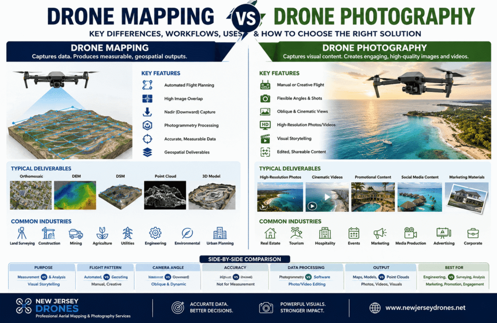
A comparison of drone mapping and drone photography, highlighting differences in workflow, software, accuracy, and deliverables.
People often use drone mapping and drone photography as if they mean the same thing. It’s an easy mistake to make since both involve flying a drone with a camera. However, once you look beyond the flight itself, the similarities end.
While both services may use the same drone, they’re built for completely different purposes. A real estate photographer might fly a DJI drone to capture eye-catching aerial images of a property, while a land surveyor could use a similar drone to collect precise spatial data from the same location. The aircraft may be identical, but the flight planning, camera settings, software, processing methods, and final deliverables are entirely different.
Drone photography is focused on creating visually appealing images and videos for marketing, storytelling, inspections, and promotional content. Drone mapping, on the other hand, captures structured aerial data that can be processed into accurate maps, 3D models, elevation data, and other geospatial products used by surveyors, engineers, construction teams, and GIS professionals.
Choosing the wrong service can lead to unnecessary costs and disappointing results. Beautiful aerial photographs won’t help an engineer calculate stockpile volumes or create contour maps, just as a survey-grade orthomosaic isn’t the right solution for a hotel looking to promote its beachfront property.
This guide explains the key differences between drone mapping and drone photography, including their workflows, software, accuracy, equipment, deliverables, and the industries where each is most valuable.
Quick Answer
Drone mapping uses overlapping aerial images, photogrammetry software, and accurate positioning technologies to create measurable outputs such as:
- Orthomosaic Maps
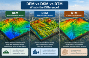
- Digital Elevation Models (DEM)
- Digital Surface Models (DSM)
- Point Clouds
- Contour Maps
- 3D Models
Drone photography focuses on producing high-quality aerial photos and videos for marketing, real estate, tourism, inspections, events, and branding. The priority is visual quality rather than measurement accuracy.
Choose Drone Mapping If You Need
- Survey-grade maps
- Accurate measurements
- Engineering deliverables
- GIS integration
- Construction monitoring
- Volume calculations
Choose Drone Photography If You Need
- Real estate marketing
- Hotel and resort promotion
- Social media content
- Tourism campaigns
- Wedding or event coverage
- Brand storytelling
Drone Mapping vs Drone Photography at a Glance
| Feature | Drone Mapping | Drone Photography |
|---|---|---|
| Primary Goal | Collect measurable geospatial data | Capture visually appealing aerial content |
| Accuracy | Survey-grade | Visual only |
| GPS | RTK / PPK recommended | Standard GPS |
| Flight Type | Automated grid missions | Manual flights |
| Image Overlap | 75-85% required | Not required |
| Processing | Photogrammetry software | Photo & video editing |
| Deliverables | Orthomosaic, DEM, DSM, Point Clouds | JPG, RAW, PNG, Videos |
| Measurements | ✔ Yes | ✖ No |
| Primary Industries | Surveying, Construction, Agriculture | Marketing, Real Estate, Tourism |
Why Do People Confuse Drone Mapping and Drone Photography?
The confusion comes from the fact that both workflows begin in almost the same way: a drone flies over an area and captures aerial images. To someone watching from the ground, the process looks identical.
The real difference begins after the images are captured.
In drone photography, every decision is made to create visually engaging content. The pilot chooses the best angle, lighting, composition, and camera movement to produce images or videos that attract attention and tell a story.
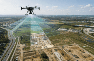
Drone mapping follows a far more structured workflow. The drone flies a pre-planned automated route at a consistent altitude while capturing hundreds of overlapping images. Those images are then processed with photogrammetry software to generate accurate maps, 3D models, elevation data, and other measurable outputs.
A simple way to remember the difference is:
Drone Photography asks:
- How can I capture the most attractive aerial image?
- Which angle creates the biggest visual impact?
- How can these visuals support the client’s marketing goals?
Drone Mapping asks:
- How can I collect accurate spatial data?
- Can this location be measured reliably?
- Will the final data support surveying, engineering, or GIS workflows?
That difference shapes every stage of the project, from flight planning and camera settings to software selection and the final deliverables.
What Is Drone Mapping?
Drone mapping is the process of collecting structured aerial imagery and converting it into accurate geospatial data using photogrammetry.If you’d like a more detailed explanation of the mapping process, read our guide on What Is Drone Mapping?
Unlike traditional aerial photography, where each image is valuable on its own, every photo captured during a mapping mission contributes to a larger dataset. Photogrammetry software analyzes the overlap between these images to reconstruct the surveyed area and generate accurate, measurable outputs.
Depending on the project, drone mapping can produce:
- Orthomosaic Maps
- Digital Surface Models (DSM)
- Digital Elevation Models (DEM)
- Point Clouds
- 3D Meshes
- Contour Maps
- Terrain Models
- Stockpile Volume Reports
- CAD-Compatible Files
- GIS Layers
These outputs are widely used in construction, surveying, mining, agriculture, utilities, environmental monitoring, transportation, and urban planning because they provide reliable data for planning, analysis, and decision-making.
Unlike standard aerial photography, drone mapping creates information that professionals can measure, analyze, and integrate into engineering or GIS workflows.
How Does Drone Mapping Work?
Drone mapping follows a structured workflow that prioritizes consistency and accuracy throughout the project.
A typical mapping mission includes:
- Define the survey area.
- Create an automated flight plan.
- Configure the flight altitude, speed, and image overlap.
- Place Ground Control Points (GCPs), if required.
- Fly the mission using an automated grid pattern.
- Capture hundreds or thousands of overlapping images.
- Process the images using photogrammetry software.
- Generate mapping products.
- Validate positional accuracy.
- Export the final deliverables.
Unlike drone photography, where every flight can be adjusted creatively, drone mapping relies on repeatable flight paths and consistent image capture to produce reliable geospatial data.
What Is Photogrammetry?
Photogrammetry is the technology that turns overlapping aerial photographs into accurate maps and 3D models.
Instead of measuring objects directly in the field, photogrammetry software identifies matching points across multiple images and calculates their exact position in three-dimensional space. The result is a detailed digital representation of the surveyed area that can be measured and analyzed.
Modern photogrammetry software can generate:
- Orthomosaic Maps
- Digital Surface Models (DSM)
- Digital Elevation Models (DEM)
- Dense Point Clouds
- 3D Meshes
- Textured 3D Models
- Contour Lines
- Volume Calculations
Some of the most widely used photogrammetry platforms include:
- Pix4D
- Agisoft Metashape
- DJI Terra
- RealityCapture
- WebODM
- DroneDeploy
Although each platform has its own strengths and workflow, they all perform the same core functions, including image alignment, camera calibration, feature matching, georeferencing, and 3D reconstruction.
Why Is Image Overlap So Important?
Image overlap is one of the most critical factors in a successful drone mapping project.
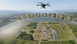
Photogrammetry software can only reconstruct an area accurately when the same ground features appear in multiple overlapping photographs. By comparing these shared features, the software calculates their precise location and builds an accurate digital model.
Professional mapping missions typically follow these overlap guidelines:
| Overlap Type | Recommended Value |
|---|---|
| Front Overlap | 75-85% |
| Side Overlap | 65-80% |
Projects involving forests, complex buildings, or uneven terrain often require even higher overlap to maintain reconstruction quality.
Insufficient overlap can lead to:
- Missing sections in the map
- Distorted orthomosaics
- Weak point clouds
- Reconstruction failures
- Reduced positional accuracy
This is why automated grid flights are the standard approach for professional mapping. They ensure consistent image coverage and provide the overlap needed for accurate photogrammetry processing.
What Are Ground Control Points (GCPs)?
Ground Control Points (GCPs) are clearly marked reference points on the ground with precisely surveyed coordinates. They help align drone imagery with real-world locations, improving the overall accuracy of a mapping project.
During processing, photogrammetry software uses these known coordinates to refine the reconstructed model and verify that the final outputs match actual ground positions.
Ground Control Points help improve:
- Horizontal accuracy
- Vertical accuracy
- Model alignment
- Georeferencing
- Overall quality assurance
They are commonly used in:
- Land Surveying
- Civil Engineering
- Highway Construction
- Mining
- Infrastructure Development
- Environmental Monitoring
Although modern RTK drones have reduced the number of GCPs needed for many projects, they remain an important part of survey-grade workflows where maximum accuracy and validation are required.
What Are RTK and PPK?
Accurate positioning is essential in professional drone mapping.
Standard GPS is suitable for general navigation, but it can introduce positioning errors that are too large for surveying and engineering applications. To improve accuracy, mapping professionals commonly rely on RTK (Real-Time Kinematic) and PPK (Post-Processed Kinematic) technologies.
| Technology | Description | Best Used For |
|---|---|---|
| RTK (Real-Time Kinematic) | Applies positioning corrections during the flight. | Construction, surveying, engineering projects |
| PPK (Post-Processed Kinematic) | Applies corrections after the flight is complete. | Remote areas and long-duration mapping missions |
Both technologies significantly improve positioning accuracy compared to standard GPS and are widely used in professional mapping workflows.
RTK (Real-Time Kinematic)
RTK receives correction data from a nearby base station or correction network while the drone is flying.
Because corrections are applied in real time, every image is tagged with highly accurate geographic coordinates. This improves the positional accuracy of the final mapping products and reduces the need for extensive ground control in many projects.
RTK is commonly used for:
- Construction monitoring
- Topographic surveys
- Infrastructure inspections
- Engineering projects
- Utility mapping
PPK (Post-Processed Kinematic)
PPK follows a different workflow.
Instead of correcting GPS data during the flight, it records raw positioning information and applies corrections after the mission using specialized processing software.
This approach is especially useful in remote areas where maintaining a continuous connection to a base station isn’t practical.
PPK is commonly used for:
- Large mining sites
- Environmental surveys
- Pipeline inspections
- Remote infrastructure projects
- Long-range mapping missions
Both RTK and PPK can deliver highly accurate positioning. The best choice depends on the project’s location, equipment, and operational requirements.
What Is Drone Photography?
Drone photography is a creative discipline focused on capturing aerial images and videos for visual communication rather than measurement.
Unlike drone mapping, where multiple overlapping images are processed into measurable datasets, each photo in a photography project is intended to stand on its own. The goal is to create compelling visuals that support marketing, branding, inspections, documentation, or storytelling.
Professional drone photography is widely used across industries such as real estate, tourism, hospitality, construction, insurance, and media because it provides perspectives that traditional ground photography cannot.
Typical deliverables include:
- High-resolution JPG images
- RAW image files
- PNG graphics
- 4K and 8K videos
- Promotional videos
- Social media content
- Website imagery
- Marketing brochures
- Construction progress photos
- Inspection photographs
These files are created for presentation and communication rather than engineering analysis or surveying.
If you’re wondering whether drone mapping can replace traditional surveying methods, read our comparison of Drone Mapping vs Land Surveying.
Why Isn’t Accuracy the Main Goal?
One of the most common misconceptions is that a high-resolution aerial photograph is automatically suitable for measurements.
In reality, image quality and positional accuracy are two different things.
A photo can look incredibly sharp while still being unsuitable for calculating distances, elevations, or surface areas.
Several factors prevent standard drone photographs from becoming survey-grade mapping products:
- Camera perspective introduces distortion.
- Lens characteristics affect object dimensions.
- Camera angles change scale across the image.
- Manual flights often vary in altitude.
- Images typically don’t have enough overlap.
- Standard GPS lacks survey-level precision.
- No photogrammetric reconstruction is performed.
For that reason, drone photography is designed to help viewers understand and appreciate a location visually rather than measure it accurately.
For example, a luxury resort uses aerial photography to showcase its pools, beachfront, and surrounding scenery, while a real estate agency uses drone images to highlight a property’s location, neighborhood, and overall appeal. In both cases, the objective is visual presentation rather than engineering analysis.
Industries That Depend on Drone Photography
Drone photography has become an essential tool across many industries because it offers perspectives that traditional ground photography simply can’t capture. While each industry has its own requirements, the goal remains the same: create high-quality visuals that inform, engage, or promote.
Real Estate
Real estate professionals use drone photography to present properties from a broader perspective, giving potential buyers a better understanding of the property’s location and surroundings.
Common uses include:
- Property boundaries
- Neighborhood overviews
- Nearby parks and schools
- Waterfront access
- Landscape design
- Roof condition
- Building exteriors
- Commercial developments
Aerial images help buyers visualize the property’s full context, something ground-level photos often can’t achieve.
Hotels and Resorts
Hotels and resorts rely on drone photography to showcase their facilities and overall guest experience.
Popular subjects include:
- Swimming pools
- Beaches
- Golf courses
- Luxury villas
- Resort layouts
- Outdoor amenities
- Scenic surroundings
Wide aerial views help potential guests appreciate the size, location, and atmosphere of a property before booking.
Tourism
Tourism boards and travel companies use drone photography to highlight destinations from unique perspectives.
Common subjects include:
- National parks
- Historic landmarks
- Coastlines
- Mountain ranges
- Lakes
- Islands
- Cultural attractions
Aerial imagery allows travelers to experience a destination visually before deciding to visit.
Weddings and Events
Drone photography captures moments that are difficult or impossible to photograph from the ground.
Typical applications include:
- Ceremony overviews
- Group photographs
- Venue layouts
- Fireworks displays
- Outdoor celebrations
- Festivals
- Sporting events
- Concerts
These aerial shots add scale, atmosphere, and storytelling to event coverage.
Marketing and Advertising
Brands increasingly use drone photography to create engaging visual content for digital and traditional marketing campaigns.
Common applications include:
- Commercial advertisements
- Product launches
- Corporate branding
- Social media campaigns
- Television commercials
- YouTube videos
- Promotional videos
- Website banners
The aerial perspective helps businesses create distinctive content that stands out across different marketing channels.
Construction Documentation
Construction companies frequently use drone photography to document site progress throughout a project.
Regular aerial images provide clients, project managers, and stakeholders with a clear visual record of how the site is developing over time. Unlike drone mapping, the focus here is on communication and documentation rather than measurements.
Insurance Inspections
Insurance companies use drone photography to safely document property conditions without placing inspectors in hazardous locations.
Common inspection tasks include:
- Roof damage
- Storm damage
- Flood impacts
- Fire damage
- Property condition reports
- Insurance claim documentation
In many cases, high-resolution aerial photographs provide enough evidence for inspections without requiring a full mapping workflow.
Creative Principles of Drone Photography
Producing professional aerial images requires more than flying a drone. Every successful photograph is shaped by creative decisions made before, during, and after the flight.
Composition
Composition determines how the elements within an image are arranged to draw the viewer’s attention.
Professional photographers commonly use techniques such as:
- Rule of Thirds
- Leading Lines
- Symmetry
- Framing
- Negative Space
- Foreground Interest
A well-composed image naturally guides the viewer toward the main subject while creating balance and visual interest.
Lighting
Lighting plays a major role in the overall quality and mood of aerial photography.
Many photographers schedule flights during:
- Golden Hour
- Blue Hour
- Sunrise
- Sunset
- Overcast conditions
- Seasonal lighting
Unlike mapping projects, which benefit from consistent lighting for accurate processing, photography often takes advantage of dramatic light and shadows to create more impactful images.
Camera Movement
When capturing video, camera movement becomes an important storytelling tool.
Popular cinematic movements include:
- Orbit Shots
- Reveal Shots
- Push-In
- Pull-Out
- Crane Movement
- Tracking Shots
- Dolly Zoom
- Fly-Through
These movements create dynamic footage that adds depth and emotion to promotional videos and marketing campaigns.
Color Grading
After the flight, photographers refine their images through post-processing to achieve a polished, professional look.
Typical editing adjustments include:
- Exposure correction
- White balance
- Contrast
- Saturation
- Vibrance
- Highlight recovery
- Shadow recovery
- Noise reduction
- Sharpening
The goal is to enhance the image while maintaining a natural appearance that reflects the client’s brand and marketing objectives.
Drone Mapping vs Drone Photography: Feature-by-Feature Comparison
Now that you’ve seen how each workflow operates independently, it’s easier to compare them side by side.
Although both use drones equipped with cameras, nearly every stage of the project, from flight planning to the final deliverables, follows a different process. Choosing the right workflow depends entirely on what you want to achieve. If you’re new to the technology, start with our Complete Guide to Drone Mapping before exploring how mapping compares with aerial photography.
Purpose
The biggest difference between drone mapping and drone photography is the project objective.
Drone Mapping is designed to collect accurate geospatial data that professionals can measure, analyze, and integrate into surveying, engineering, GIS, construction, mining, and infrastructure projects.
Drone Photography focuses on creating compelling visual content for marketing, documentation, branding, and storytelling.
Purpose Comparison
| Feature | Drone Mapping | Drone Photography |
|---|---|---|
| Primary Goal | Collect measurable geospatial data | Capture compelling visual content |
| Primary Focus | Precision & Analysis | Creativity & Storytelling |
| Typical Users | Surveyors, Engineers, GIS Specialists | Photographers, Marketers, Media Teams |
| Final Value | Measurements & Technical Analysis | Marketing & Visual Communication |
Real-World Example
A construction company may use drone mapping to calculate stockpile volumes, monitor site progress, and generate orthomosaics for engineers.
The same company may hire a drone photographer to produce promotional videos and aerial images for investors, clients, or marketing campaigns.
The aircraft may be the same, but the workflow and final deliverables are completely different.
Accuracy
Accuracy is what sets drone mapping apart from drone photography.
Every mapping mission is designed to produce reliable spatial data that professionals can measure and use with confidence. Rather than simply capturing detailed images, the goal is to create datasets that accurately represent real-world locations.
Drone photography doesn’t aim for this level of precision. A photo may look sharp and detailed, but it isn’t intended for surveying, engineering, or measurement.
To improve mapping accuracy, professionals often use:
- RTK positioning
- PPK positioning
- Ground Control Points (GCPs)
- High image overlap
- Camera calibration
- Consistent flight altitude
- Quality assurance checks
These practices help ensure the final outputs are suitable for surveying, construction, GIS, and engineering projects.
Accuracy Comparison
| Capability | Drone Mapping | Drone Photography |
|---|---|---|
| Distance Measurement | ✔ Yes | ✖ No |
| Area Calculation | ✔ Yes | ✖ No |
| Volume Calculation | ✔ Yes | ✖ No |
| Survey Applications | ✔ Yes | ✖ No |
| GIS Integration | ✔ Yes | ✖ No |
| Marketing Content | Possible | ✔ Primary Purpose |
Flight Planning
Flight planning is another major difference between the two workflows.
For drone mapping, every flight is carefully planned before takeoff. Operators use mission-planning software to create automated flight paths that maintain:
- Constant altitude
- Constant speed
- Consistent image overlap
- Straight flight lines
- Complete site coverage
This structured approach ensures every image contributes to an accurate map.
Drone photography is much more flexible. Instead of following a fixed grid, photographers adjust the drone’s position throughout the flight based on:
- Subject location
- Lighting conditions
- Camera angle
- Composition
- Wind
- Client requirements
The priority is capturing the best shot rather than collecting data for reconstruction.
Flight Planning Comparison
| Flight Planning | Drone Mapping | Drone Photography |
|---|---|---|
| Automated Grid Missions | ✔ Required | Rarely Used |
| Manual Flight | Occasionally | ✔ Primary Method |
| Constant Altitude | ✔ Required | Optional |
| Waypoints | ✔ Yes | Optional |
| Coverage Priority | High | Low |
| Creative Flexibility | Limited | Very High |
Camera Settings
Camera settings are also configured differently depending on the project’s objective.
In drone mapping, consistency is essential because every image becomes part of a larger dataset. Even small changes in exposure or white balance can affect reconstruction quality.
A typical mapping mission uses:
- Manual exposure
- Fixed white balance
- Constant shutter speed
- Fixed focus
- Nadir (straight-down) camera angle
Drone photography allows much more creative control. Photographers adjust camera settings throughout the flight to suit changing light and the desired visual style.
Common adjustments include:
- Exposure compensation
- White balance
- ISO
- Aperture (where supported)
- Shutter speed
- Camera tilt
- Lens selection
Camera Settings Comparison
| Camera Setting | Drone Mapping | Drone Photography |
|---|---|---|
| Manual Exposure | ✔ Required | Recommended |
| Fixed White Balance | ✔ Recommended | Optional |
| Motion Blur | Avoided | Creative Option |
| RAW Capture | ✔ Recommended | ✔ Recommended |
| Camera Angle | Mostly Nadir | Any Angle |
| Image Consistency | Critical | Flexible |
Image Overlap
Image overlap plays a central role in drone mapping.
Photogrammetry software needs the same ground features to appear in multiple images so it can accurately reconstruct the surveyed area. Without sufficient overlap, maps and 3D models may contain gaps or inaccuracies.
Professional mapping missions generally use:
- Front Overlap: 75-85%
- Side Overlap: 65-80%
Drone photography doesn’t require this level of overlap because each image is created to stand on its own.
Image Overlap Comparison
| Feature | Drone Mapping | Drone Photography |
|---|---|---|
| Front Overlap | 75-85% | Not Required |
| Side Overlap | 65-80% | Not Required |
| Duplicate Images | Required | Usually Avoided |
| Required for Reconstruction | ✔ Yes | ✖ No |
Processing Workflow
The biggest difference between mapping and photography appears after the flight.
Drone Mapping Workflow
- Import Images
- Align Photographs
- Camera Calibration
- Feature Matching
- Generate Sparse Point Cloud
- Build Dense Point Cloud
- Create 3D Mesh
- Generate Orthomosaic
- Create DEM & DSM
- Validate Accuracy
- Export GIS or CAD Files
Every step builds toward producing accurate geospatial data that can be measured and analyzed.
Drone Photography Workflow
- Import Images
- Select the Best Photos
- Adjust Exposure
- Correct White Balance
- Color Grade
- Crop & Retouch
- Reduce Noise
- Sharpen Images
- Export Final Files
The focus is on enhancing visual quality rather than creating measurable datasets.
Deliverables
The final deliverables clearly show the difference between the two workflows.
Drone Mapping Deliverables
- Orthomosaic Maps
- DEM
- DSM
- Point Clouds
- Contour Maps
- Terrain Models
- 3D Meshes
- Stockpile Reports
- GIS Layers
- CAD-Compatible Files
These outputs are designed for surveying, engineering, construction, and GIS analysis.
Drone Photography Deliverables
- JPG Images
- RAW Photos
- PNG Graphics
- 4K Videos
- Promotional Videos
- Social Media Content
- Website Images
- Marketing Brochures
- Inspection Photos
- Client Galleries
These files are created for marketing, communication, documentation, and branding.
Deliverables Comparison
| Deliverable | Drone Mapping | Drone Photography |
|---|---|---|
| Orthomosaic | ✔ Yes | ✖ No |
| DEM | ✔ Yes | ✖ No |
| DSM | ✔ Yes | ✖ No |
| Point Cloud | ✔ Yes | ✖ No |
| Contour Maps | ✔ Yes | ✖ No |
| CAD Files | ✔ Yes | ✖ No |
| GIS Layers | ✔ Yes | ✖ No |
| High-Resolution Photos | Possible | ✔ Yes |
| Cinematic Videos | Rare | ✔ Yes |
| Marketing Assets | Limited | ✔ Primary Output |
Key Takeaway
Drone mapping and drone photography may use the same drone, but they’re designed to solve different problems.
Choose drone mapping when your project requires accurate measurements, terrain analysis, engineering data, or GIS-ready deliverables.
Choose drone photography when your priority is creating high-quality aerial photos and videos for marketing, inspections, real estate, tourism, or visual storytelling.
The right choice ultimately depends on what you need to deliver. Understanding that difference helps you select the appropriate workflow, software, and equipment while avoiding unnecessary costs and ensuring the final results meet your project’s goals.
Accuracy in Drone Mapping: Understanding GSD, RMSE, Horizontal & Vertical Accuracy
One of the biggest advantages of drone mapping over standard aerial photography is its ability to produce accurate, measurable data. While aerial photos help you visualize a location, drone mapping provides the spatial information needed for surveying, engineering, construction, GIS, and other technical applications.
Accuracy, however, is often misunderstood.
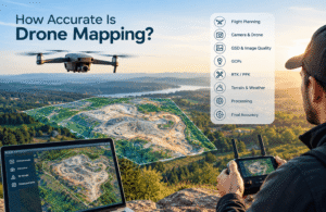
Many people assume that buying an expensive RTK drone or using a high-resolution camera automatically guarantees survey-grade results. In reality, accuracy depends on the entire mapping workflow. Flight planning, image overlap, camera calibration, positioning methods, Ground Control Points (GCPs), and quality checks all play an important role in the final outcome.
Understanding the complete mapping workflow makes it easier to see how factors like GSD, overlap, and processing affect overall accuracy. Our Drone Mapping Guide explains these concepts in more depth.
To evaluate a professional mapping project, it’s important to understand four key concepts:
- Ground Sample Distance (GSD)
- Horizontal Accuracy
- Vertical Accuracy
- Root Mean Square Error (RMSE)
Together, these measurements determine whether a drone map is reliable enough for engineering, surveying, GIS, construction, mining, or precision agriculture.
What Is Mapping Accuracy?
Mapping accuracy describes how closely a digital map matches real-world locations, dimensions, and elevations.
Every mapping project contains some degree of positional error. These small variations can result from GPS limitations, flight conditions, camera characteristics, or processing methods. Professional workflows reduce these errors through photogrammetry, while RTK, PPK, and Ground Control Points further improve positional accuracy.
Accuracy is generally evaluated in two ways:
- Horizontal Accuracy measures how precisely features are positioned along the X and Y axes.
- Vertical Accuracy measures how accurately elevations are represented along the Z axis.
The importance of each depends on the project. Road designers, for example, may prioritize horizontal accuracy, while mining and construction projects often place greater emphasis on vertical accuracy for terrain and volume calculations.
Why Accuracy Matters
Not every project requires the same level of precision.
For example:
- A tourism company creating promotional videos only needs visually appealing imagery.
- A land surveyor defining legal property boundaries requires highly accurate coordinates.
- A construction team relies on accurate elevation data for cut-and-fill calculations.
- A utility company needs precise locations of poles, transmission lines, and surrounding vegetation.
When positional errors become significant, measurements become unreliable, increasing the risk of design errors, project delays, and additional costs.
Ground Sample Distance (GSD)
Ground Sample Distance (GSD) refers to the amount of ground represented by a single pixel in an aerial image.
For example:
- 1 cm/pixel GSD means each pixel represents a 1 cm × 1 cm area.
- 3 cm/pixel GSD means each pixel represents a 3 cm × 3 cm area.
- 5 cm/pixel GSD means each pixel represents a 5 cm × 5 cm area.
A smaller GSD captures more detail because each pixel covers a smaller area on the ground.
Example
Imagine mapping a parking lot.
With a 5 cm GSD, painted parking lines are clearly visible, but small pavement cracks may not be.
With a 1 cm GSD, fine surface details, utility covers, and pavement markings become much easier to identify, making inspections and asset inventories more effective.
What Affects GSD?
Several factors influence Ground Sample Distance.
Flight Altitude
Flight altitude has the greatest impact on GSD.
- Lower altitude = Smaller GSD = Higher image detail
- Higher altitude = Larger GSD = Lower image detail
Flying lower improves detail but also requires more images to cover the same area.
Camera Sensor
Larger, higher-quality sensors capture more detail, allowing finer GSD under similar flight conditions.
Camera Resolution
Higher-resolution cameras produce more pixels, increasing image detail.
However, more megapixels don’t automatically improve mapping accuracy.
Lens Quality
Lens quality and focal length affect image sharpness and geometric consistency.
Professional mapping cameras are calibrated to reduce distortion before photogrammetry processing begins.
Does a Smaller GSD Always Mean Better Accuracy?
Not necessarily.
This is one of the most common misconceptions in drone mapping.
A map with a 1 cm GSD isn’t automatically more accurate than one with a 3 cm GSD.
If the project suffers from poor GPS positioning, inadequate image overlap, incorrect camera calibration, or weak processing, positional errors can still affect the final results.
Think of GSD as a measure of image detail, not positional accuracy.
A highly detailed image can still produce inaccurate measurements if the mapping workflow isn’t properly executed.
Horizontal Accuracy
Horizontal accuracy measures how closely mapped features match their actual position on the ground along the X and Y axes.
It determines whether roads, buildings, utilities, and property boundaries appear in the correct location.
Why It Matters
Horizontal accuracy is especially important for:
- Boundary surveys
- Utility mapping
- Road design
- GIS databases
- Infrastructure planning
- Construction layouts
For example, if a utility pole is mapped even a short distance away from its actual location, it can lead to design conflicts and construction errors.
Factors That Affect Horizontal Accuracy
Key factors include:
- RTK positioning
- PPK processing
- Ground Control Points
- Adequate image overlap
- Camera calibration
- Stable flight altitude
- Strong GPS reception
- Proper processing settings
The best results come from optimizing the entire workflow rather than relying on a single technology.
Vertical Accuracy
Vertical accuracy measures how closely mapped elevations match their true height.
Instead of focusing on position, it evaluates elevation along the Z axis.
This is especially important for:
- Terrain models
- Earthworks
- Stockpile measurements
- Drainage analysis
- Flood risk assessments
- Road grading
- Mining operations
Even small elevation errors can affect engineering calculations and material estimates.
Example
If a stockpile is measured only a few centimeters higher than its actual height, the estimated material volume may be significantly overstated, affecting inventory records and project costs.
Factors That Affect Vertical Accuracy
Vertical accuracy depends on:
- Accurate GPS positioning
- Ground Control Points
- RTK or PPK corrections
- Consistent image overlap
- Camera calibration
- Reliable terrain reconstruction
- Thorough quality assurance
Projects involving steep terrain, dense vegetation, or reflective surfaces often require additional planning to maintain reliable elevation data.
What Is RMSE (Root Mean Square Error)?
Root Mean Square Error (RMSE) is a statistical measurement used to evaluate how closely mapped coordinates match independently surveyed reference points.
In simple terms, RMSE represents the average positional error across multiple checkpoints.
A lower RMSE generally indicates better agreement between the mapped data and the known ground coordinates.
Instead of evaluating a single location, RMSE considers multiple checkpoints, making it a reliable indicator of overall mapping quality.
Why Surveyors Use RMSE
Surveyors and engineers compare mapped coordinates with independently surveyed checkpoints to verify accuracy.
Photogrammetry software uses these comparisons to generate quality reports that commonly include:
- Horizontal RMSE
- Vertical RMSE
- Number of checkpoints
- Residual errors
- Camera calibration statistics
- Image alignment quality
These reports help confirm whether the mapping project meets the required accuracy standards.
How RTK, PPK, and GCPs Improve Accuracy
Professional mapping projects often combine multiple positioning techniques to achieve more reliable results.
RTK (Real-Time Kinematic)
- Applies positioning corrections during flight
- Improves image geotag accuracy
- Reduces field time
- Supports high-precision mapping
PPK (Post-Processed Kinematic)
- Applies corrections after the flight
- Performs well in remote locations
- Useful when real-time correction networks aren’t available
Ground Control Points (GCPs)
- Provide precisely surveyed reference coordinates
- Improve horizontal and vertical accuracy
- Help validate photogrammetric reconstruction
Even when RTK or PPK is used, GCPs remain valuable for validating project accuracy and supporting quality assurance.
Common Accuracy Mistakes
Many mapping errors can be traced back to avoidable workflow mistakes.
Common examples include:
- Flying too high for the required level of detail
- Capturing insufficient image overlap
- Relying only on standard GPS
- Skipping Ground Control Points when they’re needed
- Using automatic camera settings that change between images
- Flying in strong wind or poor lighting
- Ignoring quality assurance reports after processing
Professional mapping accuracy is achieved through careful planning, consistent data collection, and thorough validation at every stage.
Expert Takeaway
Accuracy isn’t determined by the drone alone. It’s the result of a well-planned workflow.
Experienced operators combine thoughtful mission planning, appropriate Ground Sample Distance, sufficient image overlap, calibrated equipment, RTK or PPK positioning, Ground Control Points when required, and careful quality checks to produce dependable mapping results.
Instead of asking, “How accurate is this drone?”, ask:
- How will the mission be planned?
- What GSD is required?
- Will RTK or PPK be used?
- Are Ground Control Points necessary?
- How will accuracy be verified?
- Does the final dataset meet the project’s engineering or GIS requirements?
Answering these questions provides a much better indication of mapping quality than the drone’s specifications alone, helping ensure the final deliverables are accurate, reliable, and fit for their intended purpose.
Industries That Use Drone Mapping vs Drone Photography, Can One Drone Do Both?
Now that we’ve covered mapping accuracy, the next question is practical:
Where are drone mapping and drone photography actually used?
Although both use drones equipped with cameras, they’re designed for different types of work. Drone mapping helps professionals collect accurate geospatial data for measurement and analysis, while drone photography creates visual content for marketing, documentation, and storytelling.
Choosing the right workflow from the start helps ensure you collect the data your project actually needs and avoid unnecessary time and costs.
Industries That Use Drone Mapping
Drone mapping is widely used wherever accurate measurements, terrain analysis, and spatial data are essential. It allows organizations to collect detailed site information much faster than traditional ground surveys while improving efficiency and decision-making.
Land Surveying
Land surveying remains one of the most common uses of drone mapping.
Surveyors use drones to collect topographic data, monitor boundaries, and generate accurate digital terrain models.
Typical deliverables include:
- Orthomosaic Maps
- Digital Elevation Models (DEM)
- Digital Surface Models (DSM)
- Contour Maps
- Point Clouds
- CAD Files
Rather than replacing licensed surveyors, drone mapping helps them collect field data more efficiently.
Construction
Construction companies use drone mapping throughout every stage of a project.
Before Construction
- Existing site surveys
- Terrain analysis
- Project planning
- Earthwork estimation
During Construction
- Progress monitoring
- Site measurements
- Cut-and-fill calculations
- Stockpile volume analysis
- Equipment tracking
After Construction
- As-built documentation
- Project verification
- Maintenance planning
Instead of relying solely on manual site inspections, project teams can monitor progress quickly with regularly updated aerial datasets.
Mining
Mining sites change constantly, making regular mapping essential.
Drone mapping helps mining companies monitor:
- Stockpile volumes
- Open-pit development
- Haul roads
- Tailings storage
- Environmental compliance
- Site expansion
Accurate terrain models improve inventory management while reducing the need for frequent manual surveys.
Precision Agriculture
Modern farms increasingly use drone mapping to improve productivity and resource management.
Common applications include:
- Crop health monitoring
- Field variability analysis
- Drainage assessment
- Irrigation planning
- Plant emergence monitoring
- Nutrient management
When combined with multispectral imagery, drone mapping provides valuable insights that support precision farming.
Civil Engineering
Civil engineers rely on drone mapping during the planning, design, and monitoring of infrastructure projects.
Typical applications include:
- Highways
- Railways
- Bridges
- Airports
- Water infrastructure
- Utility corridors
Accurate terrain data helps reduce design uncertainty and improves planning efficiency.
Utilities
Power companies, telecommunications providers, and pipeline operators use drone mapping to manage large infrastructure networks.
Common projects include:
- Transmission corridors
- Pipeline routes
- Communication towers
- Solar farms
- Wind farms
- Electrical substations
Drone mapping enables operators to inspect and manage assets over large areas more efficiently than ground-based methods.
Environmental Monitoring
Environmental agencies use drone mapping to monitor landscape changes over time.
Common applications include:
- Coastal erosion
- River systems
- Wetlands
- Forest management
- Flood-prone areas
- Wildlife habitats
Repeating surveys at regular intervals allows organizations to compare datasets and track environmental changes more accurately.
Urban Planning
Local governments and planning agencies use drone mapping to support development and infrastructure planning.
Applications include:
- Land-use planning
- Infrastructure expansion
- Transportation planning
- Utility coordination
- Smart city initiatives
- Public works management
Up-to-date mapping data helps planners make more informed decisions than relying on outdated geographic information.
Industries That Use Drone Photography
Unlike mapping, drone photography is centered on visual communication. Its purpose is to create engaging images and videos that inform, promote, or tell a story.
Real Estate
Drone photography has become a standard marketing tool in the real estate industry.
It helps buyers understand:
- Property size
- Neighborhood surroundings
- Road access
- Landscaping
- Nearby amenities
- Waterfront views
Aerial perspectives provide context that traditional ground photography often cannot.
Hotels and Resorts
Hotels and resorts use drone photography to highlight the overall guest experience.
Common subjects include:
- Beaches
- Swimming pools
- Golf courses
- Villas
- Gardens
- Restaurants
- Ocean views
These visuals help potential guests experience the property before making a booking.
Tourism
Tourism organizations rely on aerial imagery to promote destinations through websites, social media, and advertising campaigns.
Popular subjects include:
- Mountains
- Lakes
- National parks
- Historic landmarks
- Coastlines
- Cultural attractions
Drone photography helps showcase destinations from perspectives that capture their scale and natural beauty.
Weddings and Events
Drone photography captures moments and angles that traditional cameras cannot.
Common uses include:
- Ceremony overviews
- Group photos
- Outdoor celebrations
- Festivals
- Concerts
- Sporting events
These aerial views add scale and storytelling to event coverage.
Marketing and Advertising
Businesses use drone imagery to strengthen their marketing campaigns across multiple platforms.
Typical applications include:
- Television commercials
- Product launches
- Brand films
- Social media campaigns
- Corporate websites
- Promotional videos
The aerial perspective helps brands create content that stands out.
Media Production
Film studios and content creators regularly use drones to produce cinematic footage.
Common projects include:
- Documentaries
- Television productions
- Travel programs
- YouTube content
- Feature films
- Commercial advertising
Creative camera movements and aerial perspectives help create more engaging visual stories.
Drone Mapping vs Drone Photography by Industry
| Industry | Drone Mapping | Drone Photography |
|---|---|---|
| Land Surveying | ✔ Essential | ✖ Rarely Used |
| Construction | ✔ Progress & Measurements | ✔ Marketing & Documentation |
| Mining | ✔ Essential | Limited |
| Agriculture | ✔ Crop Analysis | ✔ Farm Promotion |
| Real Estate | Limited | ✔ Essential |
| Tourism | Rare | ✔ Essential |
| Weddings | ✖ No | ✔ Essential |
| Infrastructure | ✔ Essential | ✔ Visual Documentation |
| Utilities | ✔ Asset Management | ✔ Inspection Images |
| Media Production | ✖ No | ✔ Essential |
Can Drone Photography Be Used for Mapping?
Sometimes, but only under the right conditions.
If aerial images are captured using:
- Automated flight planning
- Consistent altitude
- High front overlap
- High side overlap
- Stable camera settings
- Accurate GPS positioning
they can often be processed with photogrammetry software to generate mapping products.
However, photographs captured during a typical marketing or cinematic flight usually aren’t suitable for mapping because they’re optimized for visual appeal rather than data collection.
Common issues include:
- Inconsistent image overlap
- Changing flight altitude
- Oblique camera angles
- Motion blur
- Variable exposure
- Incomplete coverage
As a result, attractive aerial photos don’t always produce accurate maps.
Can Drone Mapping Be Used for Photography?
Yes, but with limitations.
Since mapping missions capture hundreds or thousands of high-resolution images, some can be used for documentation or general presentations.
However, mapping flights are designed for accuracy, not creativity.
Typical mapping images:
- Use a straight-down (nadir) camera angle
- Maintain fixed exposure
- Follow automated flight paths
- Prioritize overlap instead of composition
While these images work well for analysis, they usually lack the creative composition expected in marketing materials.
For promotional projects, photographers often perform a separate creative flight after completing the mapping mission.
Can One Drone Perform Both Tasks?
In many cases, yes.
Modern drones equipped with quality RGB cameras can support both mapping and photography. The difference isn’t the drone itself but how it’s flown and how the captured images are processed.
Drone Mapping Workflow
- Automated mission planning
- Fixed flight altitude
- High image overlap
- Nadir camera angle
- Photogrammetry processing
- Geospatial deliverables
Drone Photography Workflow
- Manual flight
- Creative composition
- Dynamic camera angles
- Adjustable exposure
- Photo editing
- Marketing-focused deliverables
The same drone can produce completely different results depending on the workflow.
When Should You Choose Drone Mapping?
Drone mapping is the right choice when your project requires:
- Accurate measurements
- Survey-grade deliverables
- Topographic analysis
- Volume calculations
- GIS integration
- Engineering design
- Infrastructure planning
- Asset management
- Environmental monitoring
If the data needs to be measured or analyzed, mapping is the appropriate solution.
When Should You Choose Drone Photography?
Drone photography is the better choice when your goal is to:
- Promote a property
- Showcase a destination
- Document an event
- Create social media content
- Produce marketing materials
- Capture cinematic footage
- Support branding
If the primary objective is visual communication, photography is usually the better fit.
Key Takeaway
Before planning any drone project, ask one simple question:
“What decision will this data help someone make?”
If the answer involves surveying, engineering, construction, GIS, or technical analysis, choose drone mapping.
If the goal is marketing, storytelling, promotion, or audience engagement, choose drone photography.
Starting with the project’s objective makes it easier to choose the right workflow, equipment, software, and deliverables, ensuring the final results meet the client’s actual needs rather than simply producing attractive aerial imagery.
Cost Comparison, ROI Analysis & Common Beginner Mistakes
Choosing between drone mapping and drone photography isn’t just about the technology involved. It’s also about selecting the option that delivers the most value for your project.
At first glance, a drone mapping project may seem more expensive than a photography session. However, the two services produce very different outcomes. Mapping generates measurable geospatial data that supports engineering, surveying, construction, and long-term planning. Drone photography focuses on creating high-quality images and videos for marketing, inspections, and visual communication.
Understanding the difference in cost, value, and return on investment (ROI) makes it easier to choose the workflow that best fits your goals.
Why Does Drone Mapping Cost More?
Although both services involve flying a drone, the workflow behind each project is very different.
A professional drone mapping project typically includes:
- Site assessment
- Flight planning
- Airspace verification
- Automated mission planning
- RTK or PPK setup
- Ground Control Point (GCP) placement, when required
- High-overlap image capture
- Photogrammetry processing
- Accuracy validation
- Quality assurance
- GIS or CAD exports
- Final project reporting
Drone photography usually involves a simpler workflow, including:
- Creative planning
- Lighting evaluation
- Manual flight
- Image selection
- Color correction
- Photo retouching
- Video editing (if needed)
- Final media export
Since mapping requires additional planning, specialized software, data processing, and quality checks, it generally costs more than a standard photography project.
Factors That Influence Project Cost
Project pricing depends on more than just the size of the site. Several factors can affect the overall cost.
1. Project Area
Larger sites typically require:
- Longer flight times
- More battery changes
- More images
- Longer processing times
For example, mapping a 10-acre property is much simpler than surveying a 1,000-acre construction site, even if the same drone is used.
2. Accuracy Requirements
Projects that require higher accuracy often involve:
- RTK-enabled drones
- PPK processing
- Ground Control Points
- Additional quality checks
- Experienced operators
Survey-grade deliverables naturally require more time and expertise than basic aerial documentation.
3. Terrain Complexity
Sites with challenging terrain often require additional planning.
Examples include:
- Dense forests
- Steep slopes
- Urban environments
- Industrial facilities
These locations may require:
- Higher image overlap
- Lower flight altitude
- Multiple flight missions
- Additional processing time
4. Required Deliverables
The final deliverables have a direct impact on project cost.
Basic Photography
- Edited JPG images
- Promotional videos
- Marketing content
Advanced Mapping
- Orthomosaic maps
- DEM
- DSM
- Point clouds
- Contour maps
- CAD files
- GIS layers
- Volume calculations
The more technical the deliverables, the more processing and quality control the project requires.
5. Regulatory Requirements
Some projects also involve additional administrative work, such as:
- Flight permissions
- Safety planning
- Site coordination
- Insurance requirements
- Licensed surveyor supervision
These requirements can increase the overall project cost depending on the location and industry.
Drone Mapping vs Drone Photography Cost Comparison
| Cost Factor | Drone Mapping | Drone Photography |
|---|---|---|
| Flight Planning | Extensive | Basic |
| Automated Missions | ✔ Required | Rarely Needed |
| RTK / PPK | Often Used | Rarely Used |
| Ground Control Points | Sometimes Required | Not Required |
| Processing Time | High | Moderate |
| Software Cost | Higher | Moderate |
| Deliverable Complexity | High | Low |
| Typical Project Duration | Longer | Shorter |
The cost difference isn’t simply about flying a drone. It reflects the planning, processing, software, and expertise required to produce the final deliverables.
Understanding Return on Investment (ROI)
The cheapest option isn’t always the best investment.
A project’s ROI should be measured by how much value the final deliverables provide, whether that’s improving decision-making, reducing costs, or increasing business opportunities.
ROI of Drone Mapping
Drone mapping often provides long-term operational value by helping organizations make better technical decisions.
Examples include:
Construction
Accurate site data helps monitor progress, measure completed work, and improve communication between contractors and clients.
Mining
Regular stockpile measurements reduce manual surveys and improve inventory management.
Agriculture
Mapping supports more informed irrigation, fertilization, and crop management decisions.
Utilities
Accurate asset maps simplify maintenance planning and reduce inspection time.
Engineering
Reliable terrain models help identify design issues before construction begins, reducing costly revisions later.
In these cases, the savings and operational improvements often outweigh the initial project cost.
ROI of Drone Photography
Drone photography creates value by improving how businesses present their products, properties, and services.
Examples include:
Real Estate
Professional aerial imagery helps listings attract more attention while giving buyers a better understanding of the property.
Hotels and Resorts
High-quality visuals strengthen marketing campaigns and highlight the guest experience.
Tourism
Aerial photography showcases destinations in a way that encourages visitors and supports promotional efforts.
Corporate Marketing
Drone images and videos enhance branding, advertising, websites, and social media campaigns.
While photography doesn’t produce measurable datasets, it can significantly improve brand visibility and customer engagement.
Which Service Offers Better ROI?
There’s no single answer because the best return depends on your project goals.
Choose drone mapping if you need:
- Accurate measurements
- Engineering analysis
- GIS integration
- Infrastructure planning
- Volume calculations
- Survey-grade deliverables
Choose drone photography if your priority is:
- Brand awareness
- Customer engagement
- Property marketing
- Tourism promotion
- Visual storytelling
- Promotional content
Rather than asking which service is better, focus on which one delivers the information or content your project actually requires.
Common Beginner Mistakes
Many first-time drone users choose the wrong workflow simply because they assume all aerial imagery serves the same purpose.
Here are some of the most common mistakes.
1. Choosing Photography When Mapping Is Needed
A construction company may request attractive aerial photos when the engineering team actually needs orthomosaics, terrain models, and elevation data.
The result is visually appealing content that can’t be used for technical analysis.
2. Paying for Mapping When Photography Is Enough
Not every project requires survey-grade data.
For example, a hotel promoting its beachfront property usually benefits far more from professional aerial photography than from DEMs, contour maps, or point clouds.
3. Assuming an RTK Drone Solves Everything
RTK improves positional accuracy, but it isn’t a complete solution.
Reliable mapping still depends on:
- Careful flight planning
- Consistent image overlap
- Camera calibration
- Quality assurance
- Proper data processing
High-quality results come from the workflow as a whole, not from a single hardware feature.
4. Ignoring the Required Deliverables
Before hiring a drone service provider, define exactly what you need.
Questions worth asking include:
- Do we need an orthomosaic?
- Will engineers use this data?
- Is GIS integration required?
- Are accurate measurements necessary?
- Will the images be used for marketing?
Clear answers make it much easier to choose the right service.
5. Comparing Price Instead of Value
Selecting the lowest-priced option without considering the deliverables can lead to additional costs later.
A photography project may need to be repeated if technical mapping data becomes necessary.
Likewise, investing in a full mapping workflow for a simple marketing campaign can result in unnecessary expense.
Looking beyond the initial price often leads to better long-term value.
Key Takeaway
Successful drone projects begin with a clear business objective, not the drone model or software being used.
Before choosing a workflow, ask:
- Do we need accurate measurements?
- Will this data support engineering or GIS work?
- Are we monitoring progress over time?
- Or do we simply need high-quality visuals for marketing and communication?
Answering these questions first makes the choice between drone mapping and drone photography much clearer. Once the objective is defined, it’s easier to select the right workflow, equipment, software, and deliverables, ensuring the final results provide real value instead of collecting data or imagery that doesn’t meet the project’s needs.
Professional Decision Framework
By now, you’ve seen how drone mapping and drone photography differ in their workflow, accuracy, software, costs, and deliverables. The final step is deciding which approach best fits your project.
Many projects don’t fall short because the wrong drone was used. They fail because the project objectives weren’t clearly defined from the beginning.
A simple decision-making framework can help you choose the right workflow before the drone ever leaves the ground.
Do You Need Measurements?
Start by asking what you expect from the final deliverables.
If your project requires:
- Distance measurements
- Area calculations
- Volume calculations
- Elevation models
- Terrain analysis
- GIS integration
Choose Drone Mapping.
If your goal is to create aerial photos or videos for marketing, inspections, or visual documentation,
Choose Drone Photography.
Who Will Use the Deliverables?
The end user often determines the right workflow.
| End User | Recommended Workflow |
|---|---|
| Surveyor | Drone Mapping |
| Civil Engineer | Drone Mapping |
| Construction Manager | Drone Mapping |
| GIS Analyst | Drone Mapping |
| Real Estate Agent | Drone Photography |
| Marketing Team | Drone Photography |
| Tourism Board | Drone Photography |
| Hotel Owner | Drone Photography |
If the deliverables will support technical decisions, mapping is usually the better option. If they’re intended to communicate or promote, photography is generally the right choice.
What Are the Final Deliverables?
Knowing exactly what the client expects makes the decision much easier.
Choose Drone Mapping if you need:
- Orthomosaic maps
- DEMs
- DSMs
- Point clouds
- CAD files
- GIS layers
- Contour maps
Choose Drone Photography if you need:
- High-resolution JPG images
- Social media content
- Promotional videos
- Website imagery
- Marketing brochures
- Cinematic footage
The deliverables should always guide the workflow.
Will the Site Be Monitored Over Time?
Projects involving repeated surveys usually benefit from drone mapping because data can be compared over multiple inspections.
Examples include:
- Construction progress monitoring
- Mining operations
- Infrastructure maintenance
- Environmental monitoring
- Agricultural field analysis
Using the same mapping workflow over time makes it easier to identify changes and measure progress accurately.
Buyer Checklist
Before hiring a drone service provider, use this checklist to make sure the project requirements are clearly defined.
Project Goals
- ✔ What problem are you trying to solve?
- ✔ Do you need measurements or visual content?
- ✔ Will the deliverables support engineering or marketing?
Deliverables
- ✔ Orthomosaic required?
- ✔ DEM or DSM needed?
- ✔ Point cloud required?
- ✔ 3D model required?
- ✔ High-resolution photos required?
- ✔ Promotional video required?
Accuracy Requirements
- ✔ Is RTK necessary?
- ✔ Will Ground Control Points be used?
- ✔ What level of accuracy is expected?
- ✔ How will accuracy be verified?
Software & File Formats
- ✔ Which photogrammetry software will process the data?
- ✔ Which editing software will be used?
- ✔ Are GIS-compatible exports available?
- ✔ Can CAD files be delivered?
Timeline
- ✔ When are the deliverables needed?
- ✔ Is cloud processing acceptable?
- ✔ Will multiple site visits be required?
Compliance
- ✔ Has airspace authorization been obtained?
- ✔ Are local aviation regulations being followed?
- ✔ Is the project properly insured?
- ✔ Has a safety assessment been completed?
Answering these questions before the project begins helps avoid misunderstandings and ensures everyone has the same expectations.
FAQs
Can one drone perform both mapping and photography?
Yes.
Many modern drones can handle both workflows. The difference isn’t the aircraft itself but how it’s flown, the camera settings used, and how the images are processed afterward.
Is drone mapping more expensive than drone photography?
In most cases, yes.
Mapping projects involve additional planning, specialized software, longer processing times, and more extensive quality control. You’re paying for accurate geospatial data rather than simply the flight.
Do I always need an RTK drone?
No.
Standard GPS-equipped drones are often sufficient for photography, marketing, inspections, and general documentation.
RTK or PPK becomes more valuable when projects require survey-grade accuracy for engineering, surveying, or GIS applications.
Can drone photographs be turned into maps?
Sometimes.
Images can be processed into mapping products if they’re captured using proper mapping techniques, including:
- Automated flight planning
- High image overlap
- Consistent flight altitude
- Stable camera settings
- Reliable GPS positioning
Photos captured during creative or cinematic flights usually don’t meet these requirements.
Which industries benefit most from drone mapping?
Drone mapping is widely used in:
- Land surveying
- Construction
- Mining
- Agriculture
- Utilities
- Environmental monitoring
- Civil engineering
- Urban planning
Which industries benefit most from drone photography?
Drone photography is commonly used in:
- Real estate
- Tourism
- Hospitality
- Events
- Marketing
- Advertising
- Media production
- Corporate communications
Future Trends in Drone Technology
Drone technology continues to evolve, making both mapping and photography more capable and efficient.
AI-Assisted Processing
Artificial intelligence is helping automate many parts of the processing workflow, including:
- Feature extraction
- Object detection
- Asset classification
- Defect identification
- Quality control
- Change detection
These improvements reduce manual work while helping organizations gain useful insights from aerial data more quickly.
Digital Twins
More organizations are using drone mapping to build and maintain digital twins, which are virtual representations of real-world assets.
Common applications include:
- Smart cities
- Industrial facilities
- Airports
- Manufacturing plants
- Utilities
- Large infrastructure projects
Drone mapping provides the up-to-date spatial data needed to keep these digital models accurate over time.
LiDAR Integration
While RGB photogrammetry remains the most common mapping method, LiDAR technology is becoming more accessible.
LiDAR performs particularly well in areas with dense vegetation where traditional photogrammetry may struggle.
Many organizations now combine LiDAR and RGB imagery to create more detailed and complete datasets.
Autonomous Drone Operations
Advances in autonomous flight planning are making routine inspections more efficient.
Common applications include:
- Scheduled infrastructure inspections
- Construction progress monitoring
- Solar farm surveys
- Pipeline inspections
- Asset inventories
Automated flights improve consistency while reducing the time required for repetitive data collection.
Final Verdict
Drone mapping and drone photography aren’t competing services. They’re complementary solutions designed for different objectives.
Choose drone mapping when your project requires:
- Accurate measurements
- Survey-grade deliverables
- Terrain analysis
- Volume calculations
- Engineering workflows
- GIS integration
- Long-term monitoring
Choose drone photography when your priority is:
- Marketing
- Storytelling
- Brand promotion
- Real estate listings
- Tourism campaigns
- Event coverage
- Visual documentation
The most successful drone professionals understand both workflows and select the one that best supports the client’s goals.
Conclusion
Drone mapping and drone photography may use the same aircraft and camera technology, but they serve very different purposes.
Drone mapping converts overlapping aerial images into measurable geospatial products such as orthomosaics, DEMs, DSMs, point clouds, and 3D models. These deliverables support surveying, engineering, GIS, construction, mining, agriculture, and infrastructure management.
Drone photography focuses on creating visually engaging images and videos that help businesses market properties, promote destinations, document events, and strengthen their brand through compelling aerial content.
Rather than asking “Which one is better?”, ask a more practical question:
“What decision will this project help me make?”
If you need accurate measurements, technical analysis, or spatial data, drone mapping is the right choice.
If your goal is to attract customers, showcase a property, document an event, or tell a visual story, drone photography is the better fit.
Choosing the workflow based on your project’s objectives ensures you invest in the right equipment, software, and deliverables, helping you achieve better results while maximizing the value of your investment.
For more expert guides on drone mapping, aerial photography, photogrammetry, surveying, and drone technology, visit New Jersey Drones.