What Is an Orthomosaic Map? A Beginner’s Guide
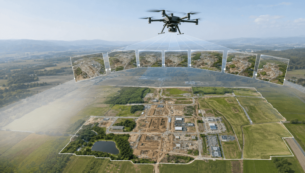
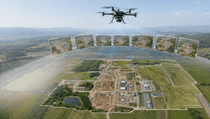
A drone captures overlapping aerial photographs to create a detailed orthomosaic map of a large site.
An orthomosaic map is a detailed aerial map created by combining many drone photos into one large image. Instead of viewing dozens or hundreds of separate photos, you can see the entire mapped area in one clear overhead view.
Orthomosaic maps are commonly used for construction sites, farms, properties, roads, mining areas, and land projects. They can help you understand a site, document changes, plan work, and take measurements when the map has been created for that purpose.
A single drone photo gives you one view of a location. An orthomosaic brings many views together.
That difference makes orthomosaic mapping useful when you need more than a simple aerial photograph.
At new jersey drones, we use drone mapping concepts to help explain how aerial data can support real-world projects. If you are completely new to drone mapping, you can first learn what drone mapping is before exploring orthomosaics.
What Is an Orthomosaic Map?
An orthomosaic map is a single aerial image made by combining multiple overlapping drone photographs.
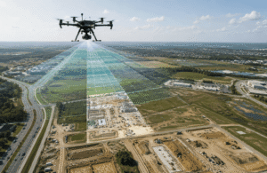
The drone flies over a planned area and captures many photographs. Each photograph overlaps with the next one. Mapping software identifies matching features between the images and joins them together.
The result is one continuous aerial map.
For example, imagine mapping a large construction site. One drone photo may show only a small part of the site. An orthomosaic can combine many photographs to show the entire area in one image.
You can then use the map to review buildings, roads, equipment, work areas, vegetation, and other visible features.
An orthomosaic is therefore more than a collection of drone photographs. It turns those photographs into a single map that is easier to review and use.
How Does an Orthomosaic Map Work?
An orthomosaic works by combining overlapping aerial photographs and adjusting them so they fit together into one consistent map.
The basic process looks like this:
- Plan the area: Decide which part of the property or site needs coverage.
- Plan the flight: Set a flight path that covers the entire area.
- Capture photos: The drone takes many overlapping photographs.
- Process the photos: Mapping software compares the images.
- Build the map: The software combines the photographs into one image.
- Check the result: Review the finished map for gaps, blurry areas, and other problems.
The quality of the final map depends heavily on the quality of the original photographs and the way the flight was planned.
If you want to understand the complete process behind drone mapping, see our Drone Mapping Guide.
How Is an Orthomosaic Map Created?
Creating an orthomosaic starts before the drone takes off.
1. Choose the Area to Map
First, decide exactly what you want to capture.
This could be:
- A construction site
- A farm
- A residential property
- A commercial property
- A road
- A quarry
- A large piece of land
Defining the area helps determine the flight path and the number of photographs required.
2. Plan the Drone Flight
The drone needs to cover the area in a planned pattern.
Random photographs can show a site, but they may not provide the consistent coverage needed for an orthomosaic.
The operator also needs to consider weather, lighting, obstacles, and the rules that apply to drone flights in the area.
3. Capture Overlapping Photographs
The drone takes photographs while flying over the site.
The photographs need to overlap because the mapping software uses shared features to connect neighboring images.
A building, road, tree, or other visible feature may appear in several photographs. Those repeated details help the software understand how the images fit together.
4. Process the Photographs
After the flight, the photographs are uploaded to mapping software.
The software compares the images and searches for features that appear in multiple photographs.
It then combines the images into a larger aerial map.
5. Review the Finished Map
The final step is checking the result.
Look for:
- Missing sections
- Blurry areas
- Gaps
- Strange shapes
- Poor image joins
- Areas with insufficient detail
A computer can combine the images, but a person should still review the final result.
What Is the Difference Between an Orthomosaic and a Regular Drone Photo?
The main difference is coverage and purpose.
A regular drone photograph shows one view of an area. An orthomosaic combines many photographs to create one large overhead map.
| Regular Drone Photo | Orthomosaic Map |
|---|---|
| Shows one view | Shows a larger area |
| Uses one photograph | Combines many photographs |
| Works well for visual content | Works well for mapping and documentation |
| Shows normal photographic perspective | Provides a map-like overhead view |
| Limited site coverage | Broad site coverage |
A regular photograph may be ideal for a website, property listing, project update, or marketing image.
An orthomosaic is more useful when you need to understand the layout of an entire site.
For example, a real estate agent may use a drone photograph to showcase a property. A land professional may use an orthomosaic to review the full property and surrounding features.
Why Is an Orthomosaic Different From a Normal Aerial Image?
A normal aerial image shows the scene from the position of the camera. Objects closer to the camera can appear larger, while objects farther away appear smaller.
An orthomosaic uses many photographs and processing methods to create a more consistent overhead representation of the area.
This makes the final image more useful for mapping.
You should not think of an orthomosaic as simply a drone photograph that has been enlarged. It is created from multiple images and processed as a complete mapping project.
The result provides a much broader view than one photograph can normally provide.
What Is an Orthomosaic Map Used For?
An orthomosaic map can support many projects because it provides a detailed aerial view of a large area.
Construction
Construction companies can use orthomosaics to document and review work sites.
Common uses include:
- Monitoring visible progress
- Documenting site conditions
- Reviewing completed work
- Comparing the site over time
- Supporting planning
- Sharing site information with project teams
For example, a construction team can create an aerial map at the beginning of a project and create another map later. Comparing the two maps can show visible changes.
This gives the team a clearer overview than individual ground photographs may provide.
Land and Property Mapping
Orthomosaics can provide a detailed visual record of land and property.
They can help you:
- Review the layout of a property
- Identify visible features
- Document land conditions
- Plan future work
- Review large areas from above
An orthomosaic does not automatically replace professional land surveying. Some projects require additional measurements and professional services.
You can learn more about the differences in our guide to drone mapping vs. land surveying.
Agriculture
Farmers can use aerial maps to view large fields from above.
An orthomosaic can help with:
- Field documentation
- Crop-area review
- Site planning
- Identifying visible changes
- Planning field inspections
For example, a farmer can use an aerial map to see field boundaries, access paths, crop areas, and other visible features in one image.
An ordinary orthomosaic shows visual information. Specialized cameras can provide different information when a project requires crop or plant analysis.
Real Estate
Real estate professionals can use orthomosaics to present large properties and surrounding land.
A detailed aerial map can show:
- Property layout
- Buildings
- Roads
- Fields
- Landscaping
- Access areas
- Surrounding features
For a large property, an orthomosaic can provide a better overall view than a single aerial photograph.
Mining and Quarries
Mining and quarry operations often cover large areas.
An orthomosaic can help teams document:
- Working areas
- Stockpiles
- Access roads
- Site conditions
- Visible changes
Repeated mapping can also create a visual record of how the site changes over time.
Infrastructure Projects
Roads, large construction areas, utility corridors, and other infrastructure projects can benefit from aerial mapping.
An orthomosaic can provide one consistent view of the project area, helping teams review conditions without relying entirely on separate ground photographs.
What Are the Benefits of an Orthomosaic Map?
An orthomosaic provides several practical benefits when the project is planned correctly.
Covers Large Areas
A drone can photograph a large site and combine the images into one map.
You can review the entire area without opening every individual photograph.
Provides Detailed Visual Information
An orthomosaic can show buildings, roads, equipment, vegetation, work areas, and other visible features.
The amount of detail depends on the camera, flight, and image quality.
Makes Comparisons Easier
You can create maps at different times and compare them.
This can help construction teams, farmers, property managers, and other users identify visible changes.
Supports Planning
A detailed aerial map can give project teams a clear view of the site before work begins.
It can also help people understand how different areas of a property relate to one another.
Simplifies Communication
One large map can be easier to share and discuss than a large collection of individual photographs.
A project manager can use the same aerial view when communicating with clients, contractors, and other team members.
Can Support Measurements
An appropriately created orthomosaic can support certain measurements.
However, measurement reliability depends on how the drone flight was planned, how the images were captured and processed, and whether additional location information was used.
You should not assume every drone-generated map provides the accuracy required for professional surveying or engineering work.
How Accurate Is an Orthomosaic Map?
There is no single accuracy level that applies to every orthomosaic map.
The final result depends on several factors.
Image Quality
Clear photographs give the mapping software more useful information.
Blurry images can reduce the quality of the final map.
Flight Planning
A well-planned flight provides consistent coverage across the site.
Poor planning can leave gaps or create areas where the software has difficulty joining photographs.
Photo Overlap
The photographs need enough shared information to connect correctly.
If neighboring images have too little overlap, the final map may contain errors or missing areas.
Weather
Wind can move trees, crops, and other objects.
Rain can affect image quality. Strong wind can also make it harder to capture consistent photographs.
Lighting
Changing light can create noticeable differences between photographs.
Strong shadows can also make some features harder to interpret.
Location Information
Some mapping projects use additional information collected on the ground to improve the map’s location and provide a way to check its position.
For projects involving engineering, land development, legal boundaries, or other important decisions, you should establish the required accuracy before collecting the images.
What Equipment Do You Need for an Orthomosaic?
You need a suitable drone, a capable camera, flight-planning software, and mapping software.
The exact equipment depends on the project.
Drone
The drone needs to fly safely over the target area and carry a suitable camera.
You do not automatically need the most expensive drone. The right choice depends on the size and requirements of your project.
Camera
The camera captures the photographs used to create the map.
Clear, consistent images make the processing stage easier and can improve the final visual result.
Flight Planning
A planned flight helps ensure that the drone captures the entire area with suitable photo coverage.
Mapping Software
The photographs need to be processed and combined using suitable software.
Different software options offer different features and workflows.
Ground Information
Some professional projects use additional information collected from known locations on the ground.
This can help establish where the map sits in the real world and provide a way to check the result.
What Can Affect the Quality of an Orthomosaic?
Several problems can affect the final map.
Blurry Photographs
Movement during image capture can create blurry images. These photographs provide less useful detail.
Missing Coverage
If part of the site is not photographed, the final map may have a gap.
Poor Overlap
The software needs enough shared information between neighboring photographs.
Moving Objects
Vehicles, people, animals, trees, and crops can move between photographs. This movement can create unusual shapes or visible joining problems.
Strong Shadows
Large shadows can hide features and create differences between photographs.
Changing Weather
Weather conditions can change during a flight and affect the consistency of the photographs.
Water Surfaces
Water can be difficult to map because reflections and changing patterns provide fewer stable features for the software to match.
Dense Vegetation
Trees and tall vegetation can hide the ground.
An aerial map may show the vegetation clearly without showing the actual surface underneath it.
These problems show why flight planning matters as much as the processing stage.
What Is the Difference Between an Orthomosaic and a 3D Model?
An orthomosaic provides a detailed overhead view, while a 3D model represents the shape, height, and depth of a site or object.
Both can come from drone photographs, but they serve different purposes.
| Orthomosaic | 3D Model |
|---|---|
| Shows an overhead view | Shows three-dimensional shape |
| Works like a detailed aerial map | Shows height and depth |
| Useful for site documentation | Useful for visualization |
| Helps review large areas | Helps understand structures and terrain |
For example, a construction company might use an orthomosaic to review the entire site and a 3D model to view the shape of buildings and other structures.
If you want to explore other mapping approaches, see Types of Drone Mapping.
Can You Create an Orthomosaic With Any Drone?
Not every drone is suitable for creating a useful orthomosaic.
The drone needs a camera capable of capturing clear photographs and enough flight capability to cover the area consistently.
A drone designed mainly for casual photography may not provide the features needed for a professional mapping project.
Before choosing a drone, consider:
- Camera quality
- Flight time
- Area size
- Image consistency
- Flight-planning options
- Mapping software compatibility
- Project requirements
The right equipment depends on the job.
A small property may have very different requirements from a large construction site.
Can a Beginner Create an Orthomosaic Map?
Yes. A beginner can learn the basic process of creating an orthomosaic.
The workflow is straightforward:
- Choose the area.
- Plan the flight.
- Capture overlapping photographs.
- Process the images.
- Review the final map.
The difficulty increases with project size and accuracy requirements.
A beginner can create a practice orthomosaic to understand how the process works. Professional projects may require more experience, better equipment, additional ground information, and careful quality checks.
There is also an important difference between creating an orthomosaic for learning and creating one for professional decisions.
If the map will support engineering, land development, legal property work, or another important purpose, identify the required standards before starting the project.
When Should You Use an Orthomosaic Map?
An orthomosaic can be a good choice when you need a detailed overhead view of a large area.
Consider using one when you need to:
- Document a construction site
- Review a large property
- Monitor visible changes
- Map a farm
- Review a quarry
- Document land conditions
- Support site planning
- Compare a location over time
- Create a detailed aerial record
Another mapping method may be better when you need information that a standard aerial camera cannot provide.
For example:
- Need heat information? Consider thermal mapping.
- Need crop or vegetation information? Consider specialized multispectral mapping.
- Need terrain information in heavily vegetated areas? Consider LiDAR.
- Need height and depth? Consider 3D mapping.
The best choice depends on the question your project needs to answer.
How Does Orthomosaic Mapping Compare With Drone Photography?
Drone photography focuses on capturing attractive or informative aerial photographs.
Orthomosaic mapping focuses on turning many aerial photographs into one useful map.
This difference matters when deciding which service you need.
If you need a few high-quality photographs for a property listing or website, standard drone photography may be enough.
If you need a complete aerial view of a large site, an orthomosaic can provide much more useful coverage.
For a detailed comparison, read Drone Mapping vs. Drone Photography.
FAQs
What is an orthomosaic map?
An orthomosaic map is a large aerial image created by combining many overlapping drone photographs. It provides a consistent overhead view that can support mapping, documentation, planning, and certain measurements.
How is an orthomosaic map made?
A drone captures overlapping photographs across a planned area. Mapping software compares shared features in those photographs and combines them into one continuous aerial map.
What is an orthomosaic used for?
Orthomosaics are used for construction, land mapping, agriculture, real estate, mining, infrastructure, property documentation, site planning, and monitoring visible changes.
What is the difference between an orthomosaic and a drone photo?
A drone photo shows one view of an area. An orthomosaic combines many photographs into one larger map-like image, making it more useful for viewing and documenting an entire site.
Can you measure distance on an orthomosaic?
Yes, an appropriately created orthomosaic can support certain measurements. Measurement reliability depends on the flight, photographs, processing, location information, and quality checks.
How accurate is a drone orthomosaic?
Accuracy varies between projects. Camera quality, flight planning, image overlap, weather, lighting, processing, and location information can all affect the final result.
What drone do you need to make an orthomosaic?
You need a drone with a suitable camera and enough capability to capture clear, overlapping photographs across the target area. The best drone depends on the size and requirements of the project.
Can a beginner create an orthomosaic?
Yes. Beginners can learn the basic process with a suitable drone, camera, flight plan, and mapping software. Professional projects may require additional experience and quality controls.
What is the difference between an orthomosaic and a 3D model?
An orthomosaic provides a detailed overhead view of an area. A 3D model represents the shape, height, and depth of a site or object.
How long does it take to create an orthomosaic?
Processing time varies according to the area size, number of photographs, computer performance, software, and processing settings. Larger projects with more images generally require more processing time.
Is an Orthomosaic Map Right for Your Project?
An orthomosaic map turns many drone photographs into one detailed aerial view. That makes it useful for construction, agriculture, property, land, mining, infrastructure, and many other projects.
The quality of the final result starts with the flight. Clear photographs, proper coverage, suitable weather, careful planning, and a quality check all affect the finished map.
The most important step is to define what you need from the project.
If you only need a few aerial photographs, drone photography may be enough. If you need a complete overhead view of a large site, an orthomosaic can be a much better fit. If you need information about heat, vegetation, terrain, or three-dimensional shape, another mapping approach may be more appropriate.
new jersey drones can help you understand the difference between these options so you can choose the approach that matches your project rather than simply choosing the most advanced technology.
For the broader process, continue with our Drone Mapping Guide.