How Does Drone Mapping Work? Step-by-Step Guide for Beginners (2026)
Learn how drone mapping works from flight planning to photogrammetry processing. Discover the complete beginner-friendly workflow, mapping outputs, equipment, and real-world applications.
Quick Answer
Drone mapping works by flying a drone over a planned area while capturing hundreds of overlapping aerial images. These images are then processed with photogrammetry software to create accurate, georeferenced maps, 3D models, elevation models, and other geospatial data.
Today, professionals in construction, agriculture, land surveying, mining, environmental monitoring, and infrastructure inspection rely on drone mapping because it provides faster data collection, accurate measurements, and a clearer view of a site than many traditional surveying methods.
Introduction
Drone mapping has changed the way professionals collect and analyze spatial data. Instead of spending days measuring land on foot, a drone can survey large areas in a single flight and produce highly detailed maps and 3D models.
Unlike regular drone photography, which is mainly used to capture attractive aerial images or videos, drone mapping focuses on collecting accurate data that can be measured, analyzed, and used for real-world decision-making.
Today, drone mapping supports a wide range of industries. Construction companies monitor project progress, surveyors create topographic maps, farmers evaluate crop health, engineers inspect infrastructure, and environmental researchers track changes across large landscapes.
The good news is that you don’t need years of experience to understand the basics. Modern mapping drones and flight-planning software automate much of the process, making drone mapping more accessible than ever for beginners.
In this guide, you’ll learn exactly how drone mapping works, from planning a mission and capturing overlapping images to processing the data into professional mapping products. By the end, you’ll have a clear understanding of the complete workflow and how each step contributes to an accurate final map.
Want to explore advanced techniques? This guide focuses on the fundamentals. If you’re ready to learn about RTK, Ground Control Points (GCPs), LiDAR, professional mapping software, aviation regulations, and survey-grade accuracy, continue with our Complete Drone Mapping Guide, where each topic is explained in greater detail.
What Is Drone Mapping?
Drone mapping is the process of using a drone to capture a series of overlapping aerial photographs and turning those images into accurate geospatial products such as orthomosaic maps, 3D models, and elevation maps.
Unlike traditional aerial photography, the goal isn’t simply to produce attractive images. Every photograph is captured according to a carefully planned flight path, with enough overlap and GPS information for specialized software to reconstruct the area accurately.
The result is data that can be measured, analyzed, and used for planning, engineering, surveying, and many other professional applications.
You may also hear drone mapping referred to by several other names, including:
- UAV Mapping
- Aerial Mapping
- Drone Surveying
- Drone Photogrammetry
- Geospatial Mapping
Although the terminology varies, the purpose remains the same: to collect reliable geographic information that helps professionals make better decisions.
Why Is Drone Mapping Different from Drone Photography?
At first glance, drone mapping and drone photography may look similar because both involve flying a drone equipped with a camera. However, their objectives are completely different.
Drone photography is designed to capture visually appealing images or videos for marketing, media, or creative projects.
Drone mapping, on the other hand, is designed to collect accurate spatial data that can be measured and analyzed.
For example, a real estate photographer might use a drone to capture stunning aerial photos of a property to attract buyers.
A land surveyor, however, uses a mapping drone to create an orthomosaic map that allows precise measurements of distances, boundaries, and land area.
This focus on measurement rather than appearance is what makes drone mapping an essential tool for construction, engineering, agriculture, surveying, and many other industries where accuracy matters.
Why Are Overlapping Images Important?
One of the most important principles behind drone mapping is image overlap.
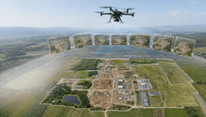
Instead of taking a handful of individual photos, the drone captures hundreds of images that intentionally overlap each other. This means the same location appears in multiple photographs taken from slightly different positions.
Why does this matter?
Photogrammetry software compares matching features across these overlapping images to calculate their exact position, elevation, and depth. The more reliable the overlap, the more accurate the final map becomes.
Without enough overlap, the software may struggle to connect the images correctly, resulting in missing sections, distorted models, or reduced accuracy.
Most mapping missions rely on two types of overlap:
- Front Overlap refers to the overlap between consecutive images captured along the flight path.
- Side Overlap refers to the overlap between images captured on adjacent flight lines.
Maintaining consistent overlap throughout the mission is one of the easiest ways to improve the quality of your mapping results.
What Is Photogrammetry?
Photogrammetry is the technology that makes drone mapping possible.
Instead of measuring land directly on the ground, photogrammetry software analyzes hundreds of overlapping photographs and identifies common features that appear in multiple images. Using those matching points, it calculates their exact location in three-dimensional space and reconstructs the landscape digitally.
Think of it as solving a giant visual puzzle. Every image provides another perspective of the same area, and the software combines all those perspectives into one accurate digital representation.
Modern mapping platforms such as Pix4D, Agisoft Metashape, DroneDeploy, DJI Terra, and WebODM use photogrammetry to generate professional mapping products that can be imported into GIS and CAD software for further analysis.
How Does Drone Mapping Work?
Drone mapping follows a structured workflow where every stage builds on the one before it. Skipping or rushing any step can affect the quality of the final results.
Although different projects may require slightly different settings, the overall process remains the same whether you’re mapping a construction site, farmland, or a large survey area.
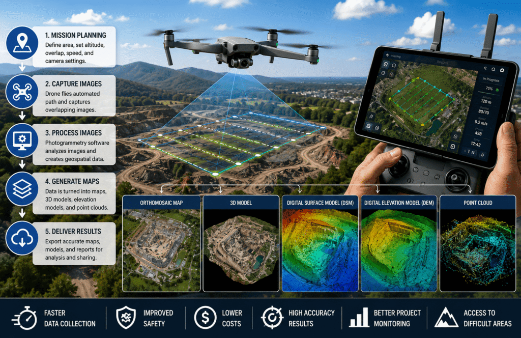
At a high level, the workflow looks like this:
| Step | Purpose |
|---|---|
| Mission Planning | Define the survey area, flight path, altitude, and camera settings. |
| Automated Flight | The drone follows the planned route automatically. |
| Image Capture | Collect overlapping aerial photographs across the entire site. |
| Image Processing | Convert images into accurate geospatial data using photogrammetry software. |
| Quality Review | Check coverage, image quality, and mapping accuracy before finalizing the project. |
| Export Deliverables | Generate maps, 3D models, reports, and other project deliverables. |
Every stage contributes to producing reliable mapping results that professionals can confidently use for analysis, planning, and decision-making.
Mission Planning
Every successful drone mapping project begins long before the drone leaves the ground.
Mission planning is where you define exactly what you want to map and configure the flight so the drone can collect complete and consistent data.
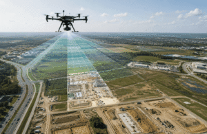
Instead of flying manually, most operators use flight-planning software to create an automated route. The software generates evenly spaced flight lines and waypoints, allowing the drone to follow a precise path while maintaining the image overlap needed for accurate photogrammetry.
Before launching the drone, operators typically configure:
- Survey boundaries
- Flight altitude
- Image overlap percentage
- Flight speed
- Camera orientation
- Takeoff and landing locations
- Local airspace restrictions
Spending a little extra time planning the mission often saves time later by reducing missing data, avoiding unnecessary repeat flights, and improving the quality of the final map.
What Types of Drone Mapping Are There?
Drone mapping isn’t a one-size-fits-all technology. Depending on the project, different sensors and mapping methods are used to collect different types of data.
Whether you’re inspecting a construction site, surveying farmland, or creating a detailed 3D model, the type of mapping you choose will affect the information you collect and the final deliverables you receive.
If you’re just getting started, don’t worry about learning every method at once. Most beginners begin with RGB photogrammetry, which is affordable, widely supported, and suitable for a wide range of mapping projects.
As your skills grow, you can explore more advanced techniques such as LiDAR, thermal, and multispectral mapping.
RGB Mapping
RGB mapping uses a standard digital camera that captures images in the red, green, and blue (RGB) color channels. It’s the most common type of drone mapping because it works well for a wide variety of industries and doesn’t require specialized equipment.
Construction companies, surveyors, engineers, and real estate professionals often rely on RGB mapping to document sites, monitor progress, and create accurate maps.
With RGB mapping, you can generate:
- Orthomosaic maps
- 3D models
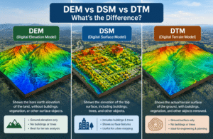
- Digital Surface Models (DSM)
- Digital Elevation Models (DEM)
- Point clouds
Since most commercial mapping drones already include a high-quality RGB camera, this is usually the best place for beginners to start.
Photogrammetry Mapping
Photogrammetry is the technology behind most modern drone mapping projects.
Instead of measuring the ground directly, photogrammetry software analyzes hundreds of overlapping images and identifies the same features across multiple photographs. It then calculates their exact position in three-dimensional space to build accurate maps and 3D models.
This approach is widely used for:
- Construction progress tracking
- Topographic surveys
- Land surveying
- Stockpile and volume calculations
- Site documentation
- Infrastructure planning
For most beginners, photogrammetry offers the perfect balance between accuracy, affordability, and ease of use. In fact, it’s the workflow used in the majority of commercial drone mapping projects today.
LiDAR Mapping
LiDAR (Light Detection and Ranging) mapping works differently from photogrammetry.
Instead of relying on photographs, a LiDAR sensor sends out thousands of laser pulses every second. By measuring how long those pulses take to return, the system builds an extremely detailed 3D representation of the terrain.
One of LiDAR’s biggest advantages is its ability to capture ground elevation beneath trees and dense vegetation, something standard camera-based mapping often struggles to do.
LiDAR is commonly used for:
- Forestry management
- Utility corridor inspections
- Flood-risk analysis
- Environmental monitoring
- High-accuracy terrain mapping
While LiDAR delivers exceptional results, it also comes with a much higher price tag. That’s why most people learn photogrammetry first before investing in LiDAR technology.
Thermal Mapping
Thermal mapping uses an infrared camera instead of a standard RGB camera.
Rather than capturing visible colors, thermal sensors detect heat differences across a surface. This allows operators to identify issues that may not be visible to the naked eye.
Thermal mapping is commonly used for:
- Building inspections
- Solar panel inspections
- Electrical infrastructure monitoring
- Search and rescue operations
- Wildlife and environmental studies
Instead of producing traditional aerial maps, thermal mapping creates heat maps that help identify temperature variations across a site.
Multispectral Mapping
Multispectral mapping captures light beyond the visible spectrum, including wavelengths such as near-infrared.
Plants reflect light differently depending on their health, moisture levels, and nutrient status. By analyzing these wavelengths, farmers and researchers can detect crop stress long before it’s visible in standard photographs.
Multispectral mapping is widely used for:
- Precision agriculture
- Crop health monitoring
- Irrigation management
- Forestry analysis
- Environmental research
Unlike RGB mapping, which focuses on visual detail, multispectral mapping provides insights into plant health and vegetation performance.
Comparison of Drone Mapping Types
| Mapping Type | Primary Sensor | Best For | Typical Output |
|---|---|---|---|
| RGB Mapping | RGB Camera | General mapping | Orthomosaics, 3D Models |
| Photogrammetry | RGB Camera | Surveying & Construction | Maps, Models, Point Clouds |
| LiDAR | Laser Scanner | Dense vegetation & terrain | High-density Point Clouds |
| Thermal | Thermal Camera | Heat inspections | Thermal Maps |
| Multispectral | Multispectral Camera | Agriculture | Vegetation Health Maps |
Each mapping method serves a different purpose. Choosing the right one depends on the type of data you need rather than simply using the most advanced sensor available.
Drone Mapping vs Drone Photography
Although both involve flying a drone with a camera, drone mapping and drone photography are designed for completely different goals.
Drone photography is all about creating visually appealing images or videos for marketing, real estate, tourism, or creative projects.
Drone mapping, on the other hand, focuses on collecting accurate spatial data that professionals can measure and analyze.
For example, a photographer might fly over a luxury property to capture eye-catching aerial shots for a listing. A surveyor flying the same property would follow an automated flight path, capture hundreds of overlapping images, and process them into a detailed orthomosaic map with measurable distances and boundaries.
Here’s a simple comparison:
| Feature | Drone Photography | Drone Mapping |
|---|---|---|
| Primary Goal | Visual content | Geographic data collection |
| Accuracy | Visual only | Measurement-based |
| GPS Integration | Optional | Essential |
| Image Overlap | Usually not required | Required |
| Software | Photo editing software | Photogrammetry software |
| Output | Photos & videos | Orthomosaics, DEMs, DSMs, 3D Models |
| Measurements | Not reliable | Accurate and measurable |
| Typical Users | Photographers, marketers | Surveyors, engineers, GIS professionals |
If your goal is to create marketing content, drone photography is usually the better option. But if you need accurate measurements, terrain analysis, or mapping products, drone mapping is the right choice.
What Data Does Drone Mapping Collect?
Drone mapping captures much more than aerial photographs.
Every flight records several layers of information that work together to create accurate geospatial data.
These include:
High-Resolution Images
The photographs captured during the flight form the foundation of every mapping project. The better the image quality, the better the final map.
GPS Coordinates
Each image is tagged with geographic coordinates, allowing the software to place every photo in its correct real-world location.
Altitude Information
The drone records its altitude throughout the flight, helping determine image resolution and overall mapping accuracy.
Camera Orientation
The position and angle of the camera are also recorded for every image. This information helps the software accurately reconstruct the landscape in three dimensions.
Metadata
Every photograph contains metadata, including:
- Capture time
- Camera settings
- GPS position
- Flight information
- Sensor details
This information allows mapping software to process the images correctly.
Geospatial Data
After processing, all of this information becomes usable geospatial data that can be imported into GIS platforms, CAD software, BIM workflows, and engineering applications.
What Information Isn’t Collected?
A standard RGB mapping drone cannot automatically detect or map everything.
For example, it cannot directly identify:
- Underground utilities
- Buried pipelines
- Soil composition
- Internal building structures
- Hidden geological formations
Projects requiring this type of information often use additional technologies such as LiDAR, Ground Penetrating Radar (GPR), or other specialized sensors.
What Can Drone Mapping Create?
One of the biggest advantages of drone mapping is the variety of deliverables it can produce from a single flight.
Depending on your project, the processed data can be transformed into several useful mapping products.
Orthomosaic Maps
An orthomosaic is a high-resolution aerial map created by stitching together hundreds of overlapping images.
Unlike a regular aerial photo, an orthomosaic is geometrically corrected, allowing users to accurately measure distances, areas, and locations.
It’s commonly used for:
- Construction progress monitoring
- Site planning
- Property documentation
- Land management
What Are the Benefits of Drone Mapping?
Drone mapping has changed the way organizations collect and analyze geographic data. Instead of relying only on traditional ground surveys that often take days to complete, drones can capture detailed aerial data in a much shorter time while improving safety and reducing overall project costs.
From construction sites and farms to mines and environmental projects, drone mapping helps teams make faster, data-driven decisions with accurate and up-to-date information.
Here are some of the biggest advantages of using drone mapping.
Faster Data Collection
One of the biggest benefits of drone mapping is speed.
A drone can survey a large area in a single flight, collecting hundreds or even thousands of high-resolution images in minutes. Tasks that might take a field crew several hours, or even days, can often be completed much more quickly.
This is especially useful for projects such as:
- Construction site surveys
- Agricultural field mapping
- Mining operations
- Infrastructure inspections
- Environmental monitoring
Because data is collected faster, teams can spend more time analyzing results instead of gathering them.
Lower Project Costs
Drone mapping can also help reduce project expenses.
Since drones automate much of the data collection process, fewer people are needed on-site, fieldwork is completed more quickly, and repeat visits are often unnecessary. Over time, this leads to lower labor costs and better overall efficiency.
For businesses that regularly survey large areas, these savings can be significant without compromising data quality.
Improved Safety
Some locations are difficult, expensive, or even dangerous to access on foot.
With drone mapping, operators can collect detailed aerial data while remaining at a safe distance, reducing the need for workers to enter hazardous environments.
Common examples include:
- Steep hillsides
- Active construction zones
- Mining pits
- Bridges and elevated structures
- Power line corridors
- Flood-damaged areas
By minimizing exposure to these risks, drone mapping helps create a safer working environment while still delivering accurate results.
High-Resolution Geographic Data
Modern mapping drones are equipped with high-quality cameras that capture detailed aerial imagery suitable for measurement and analysis.
These datasets allow professionals to:
- Measure distances accurately
- Calculate land areas
- Estimate stockpile volumes
- Monitor changes over time
- Produce detailed project documentation
The result is more reliable information that supports better planning and decision-making.
Repeatable Survey Results
Another major advantage of drone mapping is consistency.
Most mapping missions are flown using automated flight plans, allowing the drone to follow the exact same route every time. This makes it easy to compare data collected over different days, weeks, or months.
Repeatable flights are commonly used for:
- Tracking construction progress
- Monitoring crop growth
- Measuring coastal erosion
- Observing environmental restoration projects
Using the same flight path helps produce consistent datasets that reveal changes over time.
Better Project Monitoring
Regular drone flights give project teams an up-to-date view of site conditions throughout every stage of a project.
Instead of waiting for occasional site inspections, managers can compare current maps with previous ones to verify completed work, identify delays, and detect potential problems before they become costly.
This continuous visibility supports better planning and more informed decision-making.
Access to Hard-to-Reach Areas
Not every location is easy to survey from the ground.
Drones can safely reach places that are remote, uneven, or difficult for field crews to access, making them ideal for mapping challenging environments.
Examples include:
- Mountainous terrain
- Dense forests
- Wetlands
- Coastal cliffs
- Large industrial facilities
In many cases, drone mapping provides valuable data from locations that would otherwise require significant time, specialized equipment, or additional safety measures.
What Drone Mapping Cannot Do
Although drone mapping is a powerful tool, it isn’t the right solution for every project.
Weather conditions, equipment limitations, and aviation regulations can all affect the quality of the data and the success of a mapping mission. Understanding these limitations helps beginners plan more realistic and reliable projects.
Drone mapping may not perform well in situations such as:
- Heavy rain or snowfall
- Strong winds that affect flight stability
- Dense forests when using a standard RGB camera
- Highly reflective water surfaces
- Indoor environments without specialized positioning systems
- Areas with weak or unavailable GPS signals
- Restricted or no-fly zones without proper authorization
Knowing these challenges in advance makes it easier to choose the right mapping approach and avoid unnecessary problems in the field.
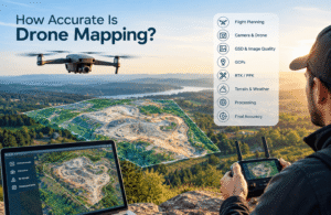
Is Drone Mapping Accurate?
Yes. When a mapping mission is carefully planned and executed, drone mapping can produce highly accurate geospatial data suitable for many professional applications.
However, accuracy doesn’t depend on the drone alone. It is the result of several factors working together throughout the entire workflow.
Flight Planning
Every accurate map starts with a well-planned mission.
Selecting the correct flight altitude, image overlap, and survey boundaries helps ensure complete image coverage and minimizes gaps in the final dataset.
Poor planning, on the other hand, can reduce both accuracy and processing quality.
Camera Quality
The camera plays an important role in mapping accuracy.
High-resolution images contain more detail, making it easier for photogrammetry software to identify matching points between photographs. Better image quality usually leads to more reliable maps and 3D models.
GPS Positioning
Each image captured during a mapping flight is tagged with GPS coordinates.
These location records help the software place every photograph in its correct geographic position, forming the foundation of an accurate map.
RTK Technology
Professional mapping projects often use Real-Time Kinematic (RTK) technology to improve positional accuracy.
RTK provides real-time GPS corrections during the flight, significantly reducing positioning errors and improving the consistency of the final map.
Learn more in our RTK vs PPK Drone Mapping Guide.
Ground Control Points (GCPs)
Ground Control Points (GCPs) are clearly marked locations on the ground with precisely surveyed coordinates.
They are used to verify and refine mapping results, particularly on large projects or when high positional accuracy is required.
Combining GCPs with RTK technology often delivers the most reliable results for professional surveying applications.
Internal Link: Read our complete Drone Mapping Accuracy Guide.
What Equipment Do Beginners Need?
You don’t need enterprise-level equipment to start learning drone mapping.
Most beginners begin with a reliable consumer drone and upgrade only when their projects require higher accuracy or specialized sensors.
Here’s the basic equipment you’ll need.
Mapping Drone
Choose a drone that offers:
- Stable GPS positioning
- A high-quality camera
- Automated flight planning support
- Good battery life
DJI remains one of the most popular choices, although several other commercial drone manufacturers also support mapping workflows.
Camera
The camera captures the images that will later be processed into maps and 3D models.
When choosing a mapping drone, look for features such as:
- High image resolution
- Sharp optics
- Mechanical shutter (if available)
- Consistent image quality
These features improve both processing quality and overall mapping accuracy.
Mapping Software
After the flight, you’ll need software to process the captured images into usable mapping products.
Popular beginner-friendly options include:
- Pix4D
- Agisoft Metashape
- WebODM
- DroneDeploy
- DJI Terra
Each platform offers different features, so the best choice depends on your workflow, budget, and project requirements.
Extra Batteries
Mapping larger areas often requires more than one flight.
Carrying additional fully charged batteries helps you complete missions without long interruptions and keeps fieldwork running efficiently.
Memory Cards
A single mapping mission can generate hundreds or even thousands of high-resolution images.
Using fast, high-capacity memory cards ensures you have enough storage and allows images to be written quickly without slowing down the camera.
Beginner Tips Before Your First Drone Mapping Flight
Your first drone mapping mission doesn’t have to be perfect. Like any new skill, you’ll improve with practice. The key is to keep things simple, prepare before takeoff, and follow a consistent workflow.
Good habits developed early can save hours of rework later. With proper planning and a few basic checks, you’ll produce cleaner datasets, avoid common mistakes, and build confidence with every flight.
Practice in an Open Area
When you’re just getting started, choose a wide, open area with as few obstacles as possible. Open fields give you plenty of space to learn how automated mapping flights work without worrying about trees, buildings, or power lines.
For your first few missions, avoid flying near:
- Buildings
- Power lines
- Tall trees
- Busy roads
- Crowded public places
A safe, open location lets you focus on learning the mapping workflow instead of constantly avoiding obstacles.
Maintain Proper Image Overlap
One of the most common reasons mapping projects fail is poor image overlap.
Every photo needs to overlap with the images around it so the software can identify matching points and stitch everything together accurately. If the overlap is too low, you may end up with missing sections, distorted models, or maps that can’t be processed properly.
Most flight-planning apps automatically recommend suitable front and side overlap settings, so it’s usually best to follow those recommendations.
Learn why overlap matters in our Drone Photogrammetry Guide.
Check the Weather Before You Fly
Weather can have a bigger impact on drone mapping than many beginners realize.
The best conditions for mapping are:
- Light or no wind
- Clear visibility
- Consistent lighting
- Dry weather with no rain or snow
Strong winds can push the drone off its planned flight path, while changing sunlight or passing clouds may affect image consistency. If the weather looks unpredictable, postponing the flight is often the better choice.
Fly at a Consistent Altitude
Keeping your drone at a steady altitude helps capture images with a consistent Ground Sampling Distance (GSD). This makes it easier for photogrammetry software to align images and produce accurate maps.
Unless you’re using terrain-following features, avoid changing altitude during the mission.
Fully Charge Your Batteries
Mapping flights often cover large areas, and one battery may not be enough to complete the job.
Before heading to the site, make sure you:
- Fully charge every flight battery
- Charge the remote controller
- Pack one or more spare batteries
- Carry a charger or power station for larger projects
Running out of battery halfway through a mission usually means repeating part of the survey, which costs both time and effort.
Understand Local Drone Regulations
Before every flight, take a few minutes to review the drone regulations that apply in your area.
Depending on where you operate, you may need to:
- Check local airspace restrictions
- Confirm whether permits are required
- Follow altitude limits
- Respect privacy laws
- Keep the drone within Visual Line of Sight (VLOS)
Rules vary from country to country, so always check the latest guidance from your local aviation authority before launching your drone.
Review Your Images Before Leaving the Site
Many beginners don’t realize something went wrong until they get back to the office. By then, returning to the site often means extra time and additional costs.
Before packing up your equipment, quickly review your images to make sure everything looks correct.
Check that:
- The entire area was captured
- Images are sharp and in focus
- GPS data has been recorded
- No flight lines are missing
- There are no obvious gaps in coverage
Spending five minutes reviewing your data on-site can save you from repeating the entire mission later.
Common Drone Mapping Mistakes to Avoid
Even experienced drone pilots make mistakes from time to time. Fortunately, most mapping problems are easy to avoid once you know what to look for.
Flying Too Fast
Flying faster doesn’t always mean working faster.
If the drone moves too quickly, images can become blurry, making it harder for photogrammetry software to create accurate maps and 3D models.
A slower, steady flight usually produces much better results.
Using Too Little Image Overlap
Low overlap is one of the leading causes of poor-quality maps.
When images don’t overlap enough, the software struggles to match common points between photographs, which can lead to gaps, processing errors, or incomplete models.
Always use the front and side overlap recommended for your mapping mission.
Flying in Windy Conditions
Strong winds can make it difficult for the drone to maintain a stable flight path.
This often leads to:
- Blurry images
- Uneven overlap
- Longer flight times
- Reduced mapping accuracy
Whenever possible, schedule mapping missions on calm days.
Incorrect Camera Settings
Image quality starts with the camera.
Before takeoff, make sure you’ve checked:
- Focus
- Exposure
- Shutter speed
- Image resolution
A few seconds spent reviewing these settings can significantly improve your final mapping results.
Changing Altitude During the Flight
Frequently changing altitude causes images to be captured at different scales, making them harder to align during processing.
For the best results, keep the drone at a consistent height throughout the mission unless the terrain requires automatic terrain-following.
Skipping Mission Planning
Successful mapping begins before the drone ever leaves the ground.
Without proper planning, you’re more likely to experience:
- Missing image coverage
- Poor overlap
- Incomplete surveys
- Additional flights
Taking a few extra minutes to plan the mission usually saves much more time later.
Ignoring Local Regulations
Flying without following local drone laws can lead to safety issues, fines, or project delays.
Make it a habit to check the rules before every flight and always operate your drone responsibly.
Common Drone Mapping Terms Every Beginner Should Know
If you’re new to drone mapping, you’ll come across a lot of technical terms. Understanding these basics will make tutorials, mapping software, and industry resources much easier to follow.
| Term | Definition |
|---|---|
| Orthomosaic | A high-resolution aerial map created by stitching together overlapping drone images. |
| Photogrammetry | The process of turning overlapping photographs into maps and 3D models. |
| GIS | Geographic Information System software used to store, analyze, and visualize spatial data. |
| GPS | A satellite-based positioning system that records the drone’s location during flight. |
| RTK | Real-Time Kinematic technology that improves GPS positioning accuracy. |
| Ground Control Points (GCPs) | Surveyed ground markers used to improve mapping accuracy. |
| DSM | A model showing the elevation of the terrain along with buildings, trees, and other surface features. |
| DEM | A model representing only the elevation of the bare ground. |
| Point Cloud | Millions of 3D points used to recreate the shape of a surveyed area. |
| Georeferencing | Assigning real-world coordinates to maps or images. |
| Waypoints | GPS coordinates that guide an automated drone flight. |
| GSD | Ground Sampling Distance, which indicates how much ground each pixel represents. |
Is Drone Mapping Right for You?
If your goal is to collect accurate measurements, monitor changes over time, or create detailed maps and 3D models, drone mapping is the better choice than standard drone photography.
The comparison below can help you decide which approach fits your project.
| Your Goal | Recommended Solution |
|---|---|
| Capture promotional photos | Drone Photography |
| Measure land accurately | Drone Mapping |
| Monitor construction progress | Drone Mapping |
| Create 3D building models | Photogrammetry |
| Analyze crop health | Multispectral Mapping |
| Map terrain beneath tree cover | LiDAR Mapping |
| Inspect infrastructure | Drone Mapping |
| Produce topographic maps | Drone Mapping |
The best workflow depends on your project goals, the type of data you need, and the equipment you have available. For most beginners, photogrammetry is the ideal starting point before moving on to advanced technologies such as RTK, LiDAR, and survey-grade mapping.
(FAQs)
What is drone mapping?
Drone mapping is the process of flying a drone over a planned area to capture overlapping aerial images. These images are processed with photogrammetry software to create accurate maps, 3D models, orthomosaics, elevation models, and other geospatial data that can be measured and analyzed.
How does drone mapping work?
Drone mapping follows a simple workflow. First, you plan the flight mission, then the drone flies an automated route while capturing overlapping images. After the flight, mapping software processes those images into accurate maps, 3D models, and terrain data that can be used for surveying, construction, agriculture, and many other applications.
Is drone mapping difficult for beginners?
Not at all. Most modern mapping drones support automated flight planning, making it easier for beginners to collect consistent aerial data. Learning the basics of mission planning, image overlap, and photogrammetry is enough to get started, while advanced skills can be developed over time.
What is the difference between drone mapping and drone photography?
Drone photography focuses on creating attractive images or videos for marketing, media, or creative projects. Drone mapping, on the other hand, captures overlapping images that are processed into accurate, measurable geographic data used for surveying, engineering, agriculture, and construction.
Do I need special software for drone mapping?
Yes. Mapping software is essential because it converts hundreds of aerial photographs into usable mapping products. Popular options include Pix4D, Agisoft Metashape, WebODM, DroneDeploy, and DJI Terra.
Which drone is best for beginners?
A beginner-friendly mapping drone should offer reliable GPS, automated flight planning, a high-resolution camera, and good compatibility with mapping software. As your experience grows, you can upgrade to RTK-enabled drones for higher positional accuracy.
How accurate is drone mapping?
Drone mapping can achieve impressive accuracy when flights are properly planned and executed. Factors such as image overlap, camera quality, GPS positioning, flight altitude, RTK technology, and Ground Control Points (GCPs) all contribute to the final accuracy of the map.
What industries use drone mapping?
Drone mapping is widely used across industries, including:
- Construction
- Land Surveying
- Agriculture
- Mining
- Infrastructure Inspection
- Environmental Monitoring
- Forestry
- Utilities
- Real Estate
- Civil Engineering
Its ability to collect fast and accurate spatial data makes it valuable for many professional workflows.
Can drone mapping replace traditional land surveying?
Drone mapping complements traditional surveying rather than replacing it entirely. While drones are excellent for covering large areas quickly and monitoring progress, licensed surveyors and conventional survey methods are still required for legal boundary surveys and certain high-precision applications.
How long does it take to complete a drone mapping project?
The time required depends on the size of the site, flight altitude, weather conditions, and processing requirements. Small projects may be completed in less than an hour, while larger sites may require multiple flights and several hours of image processing.
Conclusion
Drone mapping has transformed the way professionals collect, measure, and analyze geographic information. Instead of relying solely on traditional ground surveys, organizations can now use drones to capture high-resolution aerial imagery and convert it into accurate orthomosaics, 3D models, elevation maps, and other valuable geospatial products.
For beginners, learning how drone mapping works is the first step toward building practical skills in aerial surveying and photogrammetry. By understanding mission planning, image overlap, data processing, and mapping deliverables, you’ll have a solid foundation for producing reliable mapping results and expanding into more advanced workflows.
As your experience grows, you can explore technologies such as RTK positioning, Ground Control Points (GCPs), LiDAR, multispectral sensors, GIS integration, and survey-grade mapping techniques. These advanced tools improve accuracy and open opportunities across industries such as construction, agriculture, mining, engineering, environmental monitoring, and infrastructure inspection.
If you’re ready to move beyond the basics, continue with our Complete Drone Mapping Guide (2026), where you’ll learn about professional mapping software, RTK workflows, LiDAR mapping, accuracy optimization, regulations, best practices, and real-world applications. This beginner guide provides the foundation, while the pillar guide takes you through the complete drone mapping workflow from start to finish.