What Is Drone Mapping? A Beginner’s Guide (2026)
What Is Drone Mapping A Beginner's Guide (2026)
Drone Mapping Explained: How Drones Create Accurate Maps and 3D Models
Drone mapping has transformed the way professionals collect, measure, and analyze geographic data. Tasks that once took days or even weeks using traditional surveying methods can now be completed in a matter of hours with the help of unmanned aerial vehicles (UAVs) and mapping software. From construction sites and farmland to mining operations and environmental research, drone mapping is making data collection faster, safer, and more cost-effective.
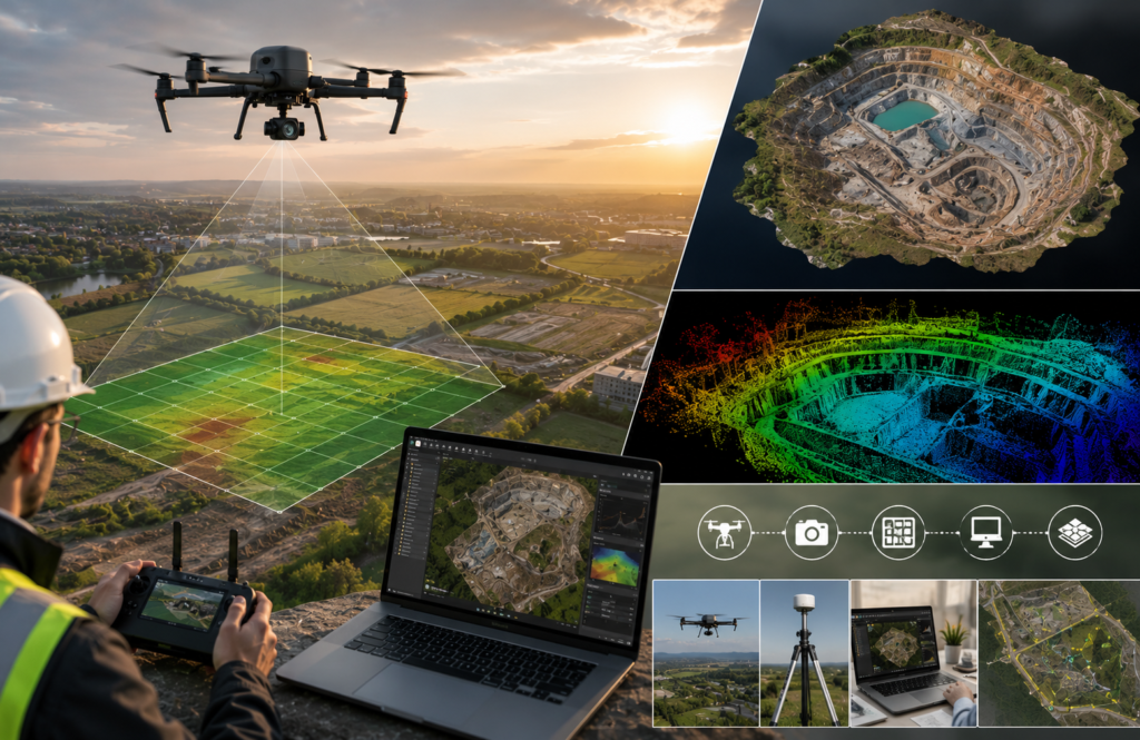
Unlike standard drone photography, drone mapping isn’t about capturing attractive aerial images. Instead, it follows a carefully planned flight path to capture hundreds or even thousands of overlapping photographs. These images are then processed using photogrammetry software to create accurate, measurable outputs such as orthomosaic maps, Digital Elevation Models (DEMs), Digital Surface Models (DSMs), point clouds, and textured 3D models.
Whether you’re a beginner exploring drone technology, a student learning about geospatial data, or a professional looking to understand aerial mapping, this guide will walk you through the fundamentals in simple language. By the end, you’ll understand how drone mapping works, where it’s used, what equipment you need, and how to take your first step toward creating accurate aerial maps.
Advanced topics such as RTK and PPK positioning, LiDAR mapping, Ground Control Points (GCPs), survey-grade accuracy, and professional software workflows are covered in our complete Drone Mapping pillar guide. This article focuses on building a strong beginner foundation.
Quick Answer
Drone mapping is the process of using a drone (UAV) to capture overlapping aerial photographs and convert them into accurate, georeferenced maps and 3D models. By combining GPS data with photogrammetry software, drones can produce orthomosaic maps, Digital Elevation Models (DEMs), Digital Surface Models (DSMs), point clouds, and other geospatial datasets used in construction, land surveying, agriculture, mining, infrastructure inspection, and environmental monitoring.
Drone Mapping at a Glance
| Feature | Details |
|---|---|
| Skill Level | Beginner |
| Reading Time | 12-15 Minutes |
| Primary Purpose | Create accurate maps and 3D models |
| Equipment Needed | Mapping Drone, Camera, Batteries, Mapping Software |
| Main Technology | Photogrammetry |
| Common Outputs | Orthomosaic, DEM, DSM, Point Cloud, 3D Model |
| Major Industries | Construction, Surveying, Agriculture, Mining, GIS |
| Next Step | Learn Professional Drone Mapping Workflow |
Who Should Read This Guide?
This beginner guide is designed for anyone who wants to understand the basics of drone mapping before moving on to more advanced surveying techniques.
It is especially useful for:
- Beginner drone pilots
- Land surveyors exploring UAV technology
- Civil engineers
- Construction managers
- GIS professionals
- Farmers using precision agriculture
- Environmental researchers
- Mining professionals
- Students studying geography, engineering, or remote sensing
- Anyone interested in aerial mapping and photogrammetry
No previous surveying experience is required. If you’re new to drones or mapping, this guide explains everything in a straightforward and beginner-friendly way.
Before You Start
You don’t need to be a surveyor or GIS expert to understand drone mapping.
However, having a basic understanding of a few concepts will make learning easier:
- Basic drone flight controls
- GPS and satellite positioning
- Digital maps
- Geographic coordinates
- Computer software basics
If these topics are unfamiliar, don’t worry. They’ll become much clearer as you work through this guide.
What Is Drone Mapping?
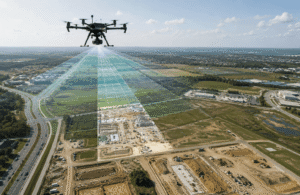
Drone mapping is the process of using an unmanned aerial vehicle (UAV), commonly known as a drone, to collect overlapping aerial images that are processed into accurate, measurable maps and 3D models.
Unlike traditional aerial photography, drone mapping is designed for precision rather than appearance. Every flight follows a carefully planned route so the drone captures each part of the survey area multiple times from slightly different angles. This image overlap allows specialized software to calculate distances, elevations, and surface details with remarkable accuracy.
The final result isn’t just a collection of photographs. Instead, the software transforms those images into useful geospatial products that professionals can measure, analyze, and use for planning or decision-making.
Common outputs include:
- Orthomosaic maps
- Digital Elevation Models (DEMs)
- Digital Surface Models (DSMs)
- Point clouds
- Textured 3D models
- Contour maps
These deliverables are widely used in industries where accurate location and measurement data are essential.
Drone Mapping vs Drone Photography
Many beginners assume that drone photography and drone mapping are the same thing, but they serve very different purposes.
Drone photography focuses on capturing visually appealing images or videos for marketing, filmmaking, or real estate listings. Drone mapping, on the other hand, is all about collecting precise spatial data that can be measured and analyzed.
For example, a photographer may capture a single aerial image of a construction site to showcase its progress. A drone mapping pilot, however, flies an automated grid pattern to capture hundreds of overlapping images that software later combines into a measurable orthomosaic or 3D model.
Simply put:
- Drone photography creates beautiful images.
- Drone mapping creates accurate geographic data.
What Makes Drone Mapping Different?
During a mapping mission, every part of the ground is photographed several times from different positions. This allows photogrammetry software to recognize common points between images and calculate their exact position in three-dimensional space.
Think about how human vision works.
Each eye sees the world from a slightly different angle. Your brain combines those two views to estimate depth and distance.
Drone mapping software works in a very similar way. Instead of using two eyes, it compares hundreds or thousands of overlapping photographs to reconstruct the shape, elevation, and position of objects on the ground.
Without sufficient overlap, the software cannot accurately generate maps or 3D models.
What Is Aerial Mapping?
Aerial mapping is the process of collecting geographic information from above rather than from the ground.
Historically, this was done using airplanes and satellites. Today, drones have made aerial mapping much more affordable, accessible, and efficient for projects of all sizes.
Once aerial images are connected to real-world GPS coordinates through a process called georeferencing, they become geospatial data that can be imported into Geographic Information System (GIS) software for measurement, analysis, planning, and visualization.
This is why drone mapping has become an essential tool in industries such as construction, surveying, agriculture, mining, environmental monitoring, and infrastructure inspection.
Key Takeaways
- Drone mapping is more than taking aerial photographs. It creates accurate, measurable geographic data.
- Automated flight planning and image overlap are essential for producing reliable maps.
- Photogrammetry software converts hundreds of aerial images into orthomosaics, 3D models, DEMs, DSMs, and point clouds.
- Drone mapping is widely used across construction, surveying, agriculture, mining, GIS, and environmental projects.
- Understanding these fundamentals provides a strong foundation before learning advanced topics such as RTK, LiDAR, Ground Control Points (GCPs), and professional mapping workflows.
How Does Drone Mapping Work?
At first glance, drone mapping might seem as simple as flying a drone and taking pictures. In reality, it’s a carefully planned workflow that combines automated flight planning, GPS positioning, high-resolution photography, and photogrammetry software to produce accurate maps and 3D models.
Each stage builds on the previous one. If one step is done incorrectly, such as poor flight planning or insufficient image overlap, the final map may contain gaps or inaccurate measurements.
The complete drone mapping process typically follows six key stages.
| Step | What Happens | Why It Matters |
|---|---|---|
| 1. Plan the Mission | Define the survey area and flight settings | Ensures complete site coverage |
| 2. Fly the Drone | Drone follows an automated flight path | Captures consistent aerial data |
| 3. Capture Images | Take overlapping photographs | Provides enough data for photogrammetry |
| 4. Process Images | Software aligns and stitches images | Creates accurate maps and models |
| 5. Review Results | Check quality and accuracy | Detects missing areas or processing errors |
| 6. Export Deliverables | Generate final maps and reports | Share results with clients or project teams |
The Drone Mapping Workflow
Step 1: Mission Planning
Mission planning is the foundation of every drone mapping project. Before the drone ever leaves the ground, you need to define exactly what area will be mapped and how the flight will be carried out.
Instead of manually flying around the site, mapping pilots use dedicated flight-planning software to create an automated flight path. The software generates a grid pattern that ensures the drone captures every part of the survey area with consistent coverage.
During this stage, you’ll typically configure:
- Survey boundaries
- Flight altitude
- Camera angle
- Flight speed
- Front overlap percentage
- Side overlap percentage
- Image capture interval
- Takeoff and landing location
Once everything is configured, the drone can fly the mission automatically with minimal manual control.
Why Mission Planning Matters
Good mission planning helps:
- Capture complete site coverage
- Improve mapping accuracy
- Reduce processing errors
- Prevent missing areas
- Produce cleaner orthomosaics and 3D models
A poorly planned mission often leads to gaps in the final map, requiring another flight and additional processing time.
Step 2: Flying the Drone
After the mission has been planned, the drone takes off and follows the programmed route automatically.
Rather than flying randomly, it moves in a systematic grid or lawnmower pattern across the site. This ensures every section of the ground is photographed multiple times from different positions.
During the flight, the drone continuously records:
- GPS location
- Flight altitude
- Camera orientation
- Flight speed
- Image timestamps
Modern mapping drones use GPS or GNSS positioning to maintain consistent flight paths and image spacing throughout the mission.
Although the flight is automated, the pilot must continue monitoring the drone to ensure safe operation and comply with local aviation regulations.
Step 3: Capturing Overlapping Images
Image capture is one of the most important parts of drone mapping.
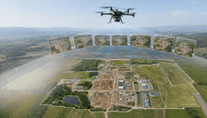
Unlike regular aerial photography, mapping requires every part of the survey area to appear in several different images. This is known as image overlap.
Two types of overlap are used:
Front Overlap
This refers to how much one image overlaps with the next image as the drone moves forward.
Higher front overlap provides more matching points for photogrammetry software, improving overall accuracy.
Side Overlap
Side overlap measures how much adjacent flight lines overlap with one another.
Without enough side overlap, software may struggle to connect neighboring images, leading to gaps or distortions in the final map.
Why Is Image Overlap Important?
Photogrammetry software works by identifying identical points that appear in multiple photographs.
The more overlap available, the easier it becomes for the software to accurately calculate:
- Distance
- Elevation
- Surface shape
- Object position
Insufficient overlap is one of the most common reasons beginner mapping projects fail.
Step 4: Processing the Images
Once the flight is complete, all captured images are transferred to drone mapping software for processing.
This is where hundreds or even thousands of individual photographs are transformed into usable geographic data.
The software performs several complex tasks automatically, including:
- Detecting matching points between images
- Aligning photographs
- Calculating camera positions
- Building a dense point cloud
- Creating elevation models
- Stitching images into one seamless map
Although the mathematics behind photogrammetry is highly advanced, beginners only need to understand that the software compares overlapping photographs to reconstruct the real world in three dimensions.
Popular Drone Mapping Software
Several software platforms are commonly used for processing mapping data.
| Software | Best For |
|---|---|
| Pix4D | Professional surveying and mapping |
| Agisoft Metashape | Advanced photogrammetry |
| DroneDeploy | Construction and agriculture |
| DJI Terra | DJI enterprise workflows |
| WebODM | Free and open-source mapping |
| RealityCapture | High-speed 3D reconstruction |
Each platform follows a similar workflow, although features and automation levels vary.
Step 5: Reviewing the Results
Processing isn’t the final step.
Before sharing any deliverables, it’s important to verify that the generated maps and models are complete and accurate.
Professionals usually check:
- Missing image areas
- Blurry photographs
- Processing errors
- Distorted sections
- Alignment accuracy
- Overall map quality
If significant issues are found, another mapping flight may be required to capture additional images.
Reviewing the output before leaving the project site can save considerable time and prevent costly rework.
Step 6: Exporting the Final Deliverables
Once quality checks are complete, the processed data can be exported into various formats depending on the project’s requirements.
Common deliverables include:
- Orthomosaic maps
- Digital Surface Models (DSM)
- Digital Elevation Models (DEM)
- Point clouds
- Textured 3D models
- Contour maps
- Volume calculations
- Measurement reports
These outputs can then be imported into GIS, CAD, BIM, or engineering software for further analysis and planning.
What Types of Drone Mapping Are There?
Not every mapping project collects the same type of data. Different sensors and workflows are used depending on the project’s objectives.
The five most common types of drone mapping are:
| Mapping Type | Primary Purpose | Common Industries |
|---|---|---|
| RGB Mapping | General aerial mapping | Construction, Real Estate |
| Photogrammetry Mapping | 3D models and measurements | Surveying, Engineering |
| LiDAR Mapping | Terrain beneath vegetation | Forestry, Mining |
| Thermal Mapping | Heat detection | Solar, Utilities, Roof Inspection |
| Multispectral Mapping | Plant health analysis | Precision Agriculture |
Let’s look at each one in more detail.
RGB Mapping
RGB mapping uses a standard digital camera to capture images in the visible light spectrum.
Because most commercial drones already include an RGB camera, this is the most common and beginner-friendly form of drone mapping.
RGB mapping is widely used for:
- Construction progress monitoring
- Property mapping
- Land documentation
- Site inspections
- Orthomosaic creation
For beginners, RGB mapping is usually the best place to start before moving to more advanced sensors.
Photogrammetry Mapping
Photogrammetry is the process of turning overlapping aerial photographs into measurable maps and realistic 3D models.
Rather than relying on expensive sensors, photogrammetry uses sophisticated algorithms to calculate depth and elevation from ordinary images.
Typical outputs include:
- Orthomosaics
- Point clouds
- DSMs
- DEMs
- 3D textured models
Today, photogrammetry forms the backbone of most commercial drone mapping projects.
LiDAR Mapping
LiDAR (Light Detection and Ranging) uses laser pulses instead of photographs to measure distance.
Unlike cameras, LiDAR can penetrate small gaps in vegetation, making it ideal for mapping forests, rugged terrain, and areas where the ground is hidden beneath tree canopies.
LiDAR is commonly used for:
- Forestry
- Utility corridor mapping
- Flood modeling
- Topographic surveys
- Mining
Because LiDAR equipment is significantly more expensive than RGB cameras, it’s generally considered an advanced drone mapping technology.
Thermal Mapping
Thermal mapping uses infrared sensors to measure heat rather than visible light.
Instead of producing standard photographs, thermal cameras reveal temperature differences across a surface.
Common applications include:
- Solar panel inspections
- Electrical system monitoring
- Building heat-loss analysis
- Roof leak detection
- Search and rescue operations
Thermal mapping helps identify problems that may not be visible to the naked eye.
Multispectral Mapping
Multispectral cameras capture wavelengths beyond visible light, including near-infrared bands.
This additional information helps detect subtle changes in vegetation that standard cameras cannot see.
Multispectral mapping is widely used for:
- Crop health monitoring
- Irrigation planning
- Disease detection
- Precision agriculture
- Environmental research
Farmers can use this data to make informed decisions about irrigation, fertilization, and crop management.
Key Takeaways
- Drone mapping follows a structured six-step workflow, from mission planning to exporting final deliverables.
- Automated flight planning and consistent image overlap are essential for accurate results.
- Photogrammetry software converts aerial photographs into measurable maps, elevation models, point clouds, and 3D models.
- RGB, photogrammetry, LiDAR, thermal, and multispectral mapping each serve different industries and project requirements.
- Understanding the mapping workflow helps beginners build a solid foundation before learning advanced topics such as RTK, PPK, LiDAR workflows, and survey-grade accuracy.
Drone Mapping vs Drone Photography
Many people assume that drone mapping and drone photography are the same because both involve capturing aerial images. While they use similar equipment, their purpose and end results are completely different.
Drone photography is primarily focused on creating visually appealing photos or videos for marketing, real estate, tourism, filmmaking, or social media. The goal is to capture the best-looking image from the best angle.
Drone mapping, however, is designed to collect accurate geographic data that can be measured, analyzed, and used for planning. Instead of taking a handful of photos, the drone follows an automated flight path and captures hundreds or even thousands of overlapping images. These images are then processed into orthomosaic maps, elevation models, point clouds, and 3D models.
In simple terms:
- Drone photography tells a visual story.
- Drone mapping provides measurable geographic information.
Drone Mapping vs Drone Photography Comparison
| Feature | Drone Photography | Drone Mapping |
|---|---|---|
| Primary Purpose | Visual content | Accurate mapping and measurement |
| Flight Method | Manual flight | Automated flight mission |
| Number of Images | A few images | Hundreds or thousands |
| Image Overlap | Usually not required | Essential |
| GPS Data | Optional | Required |
| Measurements | Not reliable | Highly accurate |
| Software Used | Photo editing software | Photogrammetry & GIS software |
| Final Output | Photos and videos | Orthomosaics, DEMs, DSMs, Point Clouds, 3D Models |
| Common Users | Photographers, Realtors | Surveyors, Engineers, Construction Teams |
For beginners, understanding this difference is important because owning a drone does not automatically mean you are creating mapping data. Accurate mapping requires proper planning, consistent image overlap, and specialized processing software.
What Data Does Drone Mapping Collect?
A drone mapping mission collects much more than aerial photographs. Every image contains valuable information that helps mapping software recreate the surveyed area with impressive accuracy.
The drone records both visual data and location data during every flight.
A Typical Mapping Mission Collects
- High-resolution aerial photographs
- GPS coordinates
- Drone altitude
- Camera orientation (Yaw, Pitch, Roll)
- Flight path information
- Image timestamps
- Camera settings
- Sensor metadata
All of this information is stored together and later processed by photogrammetry software to build accurate maps and three-dimensional models.
High-Resolution Images
The photographs captured during a mapping mission form the foundation of the entire project. These images are taken at regular intervals while maintaining sufficient front and side overlap.
Clear, sharp images allow the software to identify matching points between photographs, improving overall mapping accuracy.
GPS Coordinates
Every image is tagged with geographic coordinates recorded by the drone’s GPS or GNSS receiver.
These coordinates tell the software exactly where each image was captured, making it possible to georeference the final map.
Flight Altitude
The drone continuously records its altitude throughout the mission.
Flight height directly affects:
- Ground resolution
- Area coverage
- Mapping accuracy
- Image scale
Higher flights cover larger areas, while lower flights capture greater detail.
Camera Orientation
The drone also records the direction the camera is facing when each photograph is taken.
This information includes:
- Pitch
- Roll
- Yaw
These measurements help software correctly align images during processing.
Metadata
Every photograph includes metadata, often called EXIF data.
Typical metadata contains:
- Date and time
- Camera model
- Lens information
- Exposure settings
- ISO
- Shutter speed
- GPS coordinates
Although beginners rarely work directly with metadata, it plays an important role during image processing.
What Can Drone Mapping Create?
One of the biggest advantages of drone mapping is that a single flight can produce several valuable outputs.
Each output serves a different purpose depending on the project.
Orthomosaic Maps
An orthomosaic is one of the most common products created during drone mapping.
It is a single, seamless aerial map produced by stitching together hundreds or thousands of overlapping images.
Unlike a regular aerial photograph, an orthomosaic is corrected for:
- Lens distortion
- Camera angle
- Terrain variation
- Perspective
The result is a highly accurate map that can be measured like a traditional survey map.
Common Uses
- Site planning
- Construction progress
- Property mapping
- Infrastructure inspection
- Agriculture
3D Models
Photogrammetry software can also create realistic three-dimensional models of the mapped area.
These models allow users to:
- Rotate the site
- Zoom in
- Measure structures
- Inspect buildings
- Visualize terrain
3D models are widely used in construction, architecture, mining, archaeology, and engineering.
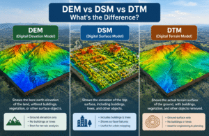
Digital Surface Model (DSM)
A Digital Surface Model represents everything visible on the Earth’s surface.
That includes:
- Buildings
- Trees
- Utility poles
- Vehicles
- Bridges
- Vegetation
Since the DSM includes all above-ground objects, it provides a realistic representation of the site’s surface.
Digital Elevation Model (DEM)
A Digital Elevation Model focuses only on the bare earth.
Buildings, trees, and vegetation are removed so the model represents the underlying terrain.
DEMs are commonly used for:
- Flood analysis
- Drainage planning
- Land development
- Road design
- Engineering projects
Although DSM and DEM sound similar, they serve different purposes depending on the project requirements.
Point Clouds
A point cloud is a dense collection of millions of individual points in three-dimensional space.
Each point contains:
- X coordinate
- Y coordinate
- Z elevation
Together, these points recreate the shape of the mapped surface with remarkable detail.
Point clouds are widely used in:
- Surveying
- BIM
- Engineering
- Construction
- Mining
Contour Maps
Contour maps display lines that connect locations with the same elevation.
These lines make it easier to understand:
- Terrain shape
- Hills
- Slopes
- Drainage
- Earthwork requirements
Civil engineers and surveyors often rely on contour maps during planning and design.
Common Drone Mapping Deliverables
| Deliverable | Description | Common Use |
|---|---|---|
| Orthomosaic | Distortion-free aerial map | Surveying, Construction |
| 3D Model | Realistic digital site model | Engineering, Architecture |
| DSM | Elevation including buildings and trees | Infrastructure Planning |
| DEM | Bare-earth elevation model | Land Development |
| Point Cloud | Millions of 3D measurement points | BIM & Surveying |
| Contour Map | Elevation lines | Civil Engineering |
Where Is Drone Mapping Used?
Drone mapping has become an essential tool across many industries because it delivers accurate information quickly while reducing costs and improving safety.
Below are some of the most common applications.
Construction
Construction companies use drone mapping throughout the entire project lifecycle.
Typical applications include:
- Monitoring project progress
- Comparing work against design plans
- Measuring stockpile volumes
- Earthwork calculations
- Site documentation
Regular drone flights help project managers identify delays and make informed decisions without relying solely on manual inspections.
Agriculture
Modern farming increasingly relies on drone mapping to improve productivity.
Using RGB and multispectral imagery, farmers can:
- Monitor crop health
- Detect irrigation problems
- Identify pest damage
- Estimate crop yields
- Optimize fertilizer application
This approach, often called precision agriculture, helps reduce waste while improving overall farm efficiency.
Mining
Mining companies use drone mapping to survey large sites safely and efficiently.
Common uses include:
- Stockpile volume calculations
- Pit monitoring
- Haul road planning
- Environmental compliance
- Progress reporting
Compared with traditional surveying methods, drones can collect data much faster while minimizing exposure to hazardous environments.
Land Surveying
Drone mapping has become a valuable tool for surveyors working on large or difficult-to-access sites.
Surveying professionals commonly use drones for:
- Topographic surveys
- Boundary planning support
- Terrain modeling
- Corridor mapping
- Site documentation
While drones greatly improve efficiency, they often complement rather than replace traditional ground surveying, particularly when legal-grade precision is required.
Real Estate
Drone mapping provides buyers, developers, and investors with a much better understanding of a property’s size, layout, and surroundings.
Common applications include:
- Large property marketing
- Land development planning
- Commercial site visualization
- Residential developments
Interactive orthomosaics and 3D models offer far more detail than standard aerial photographs.
Infrastructure Inspection
Inspecting infrastructure manually can be time-consuming and potentially dangerous.
Drone mapping allows engineers to inspect:
- Roads
- Bridges
- Railways
- Pipelines
- Power lines
- Solar farms
High-resolution imagery helps identify cracks, erosion, vegetation growth, and structural issues while reducing the need for workers to access hazardous areas.
Environmental Monitoring
Researchers and environmental organizations use drone mapping to observe changes in landscapes over time.
Applications include:
- Coastal erosion monitoring
- Wetland conservation
- Forest management
- Wildlife habitat studies
- Flood assessment
- Disaster response
Repeated drone surveys make it easy to compare changes across weeks, months, or years.
Key Takeaways
- Drone mapping collects both aerial imagery and precise geographic data during every flight.
- A single mapping mission can generate orthomosaics, 3D models, DSMs, DEMs, point clouds, and contour maps.
- Drone mapping is widely used in construction, agriculture, mining, land surveying, real estate, infrastructure inspection, and environmental monitoring.
- Unlike drone photography, drone mapping is designed for accurate measurement, analysis, and informed decision-making.
- Understanding the different outputs helps beginners choose the right workflow and deliverables for their projects.
Benefits of Drone Mapping
Drone mapping has quickly become the preferred method for collecting aerial data because it offers a faster, safer, and more cost-effective alternative to many traditional surveying techniques. Whether you’re managing a construction project, monitoring crops, or inspecting infrastructure, drone mapping helps you gather detailed information in less time without sacrificing data quality.
Instead of sending teams into the field for days, a single drone flight can capture thousands of data points across a large area. The result is a highly detailed digital map that supports better planning and decision-making.
Why Is Drone Mapping Better Than Traditional Data Collection?
Drone mapping offers several advantages over conventional ground surveys and manual inspections.
Faster Data Collection
One of the biggest benefits of drone mapping is speed.
A drone can survey large sites in a fraction of the time required by traditional field crews. Projects that once took several days can often be completed within a few hours.
This makes drone mapping especially valuable for:
- Construction sites
- Agricultural fields
- Mining operations
- Large infrastructure projects
Lower Operational Costs
Drone mapping can reduce project costs by minimizing labor, equipment, and field time.
Because fewer personnel are required on-site, businesses can complete surveys more efficiently while lowering operational expenses.
Cost savings often come from:
- Fewer field visits
- Reduced equipment rental
- Faster project completion
- Less manual data processing
Improved Safety
Many mapping projects involve hazardous environments such as highways, steep slopes, active construction sites, or mining operations.
Using drones allows operators to collect aerial data without placing workers in dangerous locations.
Common high-risk environments include:
- Quarries
- Roof inspections
- Bridges
- Power lines
- Flood zones
- Disaster areas
Keeping survey teams out of hazardous locations significantly improves workplace safety.
High-Resolution Data
Modern mapping drones capture extremely detailed aerial imagery.
These high-resolution images make it possible to identify:
- Surface cracks
- Drainage patterns
- Vegetation changes
- Construction progress
- Stockpile boundaries
- Terrain features
The greater the image quality, the more reliable the final mapping products become.
Repeatable Flights
One major advantage of automated flight planning is consistency.
The same mission can be flown repeatedly using identical flight paths and camera settings.
This allows organizations to compare changes over time, making it ideal for:
- Construction progress tracking
- Environmental monitoring
- Mining operations
- Agricultural field analysis
Easy Progress Monitoring
Drone mapping provides a visual record of how a site changes over time.
Weekly or monthly flights help project managers:
- Compare project stages
- Identify delays
- Measure completed work
- Track earthmoving progress
- Improve project reporting
Instead of relying only on written reports, stakeholders can review accurate aerial maps showing actual site conditions.
Access to Difficult Locations
Some locations are difficult, expensive, or unsafe to reach on foot.
Drones can safely capture data from:
- Mountainous terrain
- Dense vegetation
- Coastal cliffs
- Wetlands
- Large industrial sites
- Disaster zones
This flexibility allows mapping projects to be completed where traditional methods may be impractical.
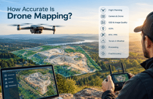
Is Drone Mapping Accurate?
A common question among beginners is whether drone mapping is accurate enough for professional work.
The answer is yes, but accuracy depends on several factors working together rather than on the drone alone.
When flights are planned correctly and processed using reliable software, drone mapping can produce highly accurate maps suitable for many engineering, construction, agricultural, and surveying applications.
For projects that require survey-grade precision, professionals often combine drone mapping with RTK technology and Ground Control Points (GCPs).
What Affects Drone Mapping Accuracy?
Several factors influence the quality and accuracy of the final map.
GPS Accuracy
Every image captured by the drone includes GPS coordinates.
More accurate positioning leads to better alignment between images and more reliable map outputs.
Professional drones often support advanced GNSS systems for improved positioning.
Camera Quality
High-quality cameras capture sharper images with more detail.
Better image quality allows photogrammetry software to identify common points more accurately, resulting in cleaner maps and more detailed 3D models.
Flight Altitude
Flight height affects both coverage and image resolution.
Lower flights generally produce:
- Higher image resolution
- Greater detail
- Better measurement accuracy
Higher flights cover larger areas but reduce the level of detail captured.
Selecting the correct altitude depends on the project’s objectives.
Image Overlap
Consistent front and side overlap is one of the most important factors in successful drone mapping.
Too little overlap can lead to:
- Processing errors
- Missing sections
- Distorted models
- Poor alignment
Most mapping missions use high overlap percentages to ensure reliable photogrammetry results.
Weather Conditions
Weather plays a significant role in mapping quality.
Strong winds can cause:
- Motion blur
- Uneven image spacing
- Flight instability
Rain, fog, and poor lighting can also reduce image quality and make processing more difficult.
Calm, clear weather generally produces the best results.
What Is RTK?
RTK (Real-Time Kinematic) is an advanced GPS correction technology that significantly improves the positional accuracy of drone mapping.
Instead of relying only on standard GPS signals, RTK drones receive correction data from a nearby base station or correction network while flying.
This reduces positioning errors and produces much more accurate maps.
Benefits of RTK
- Higher positioning accuracy
- Improved map alignment
- Reduced processing corrections
- Faster workflows
- Better engineering and surveying results
RTK is commonly used in professional surveying, construction, mining, and infrastructure projects where precision is critical.
What Are Ground Control Points (GCPs)?
Ground Control Points, commonly called GCPs, are clearly marked reference points placed on the ground before the drone flight begins.
Each point has a precisely surveyed geographic coordinate.
After the flight, these known coordinates are used to verify and improve the accuracy of the generated map.
Why Are GCPs Important?
Ground Control Points help:
- Improve overall map accuracy
- Reduce positional errors
- Validate photogrammetry results
- Produce survey-grade deliverables
Although many modern RTK drones reduce the need for numerous GCPs, they are still widely used on high-accuracy mapping projects.
RTK vs GCP
Many beginners confuse RTK and Ground Control Points, but they serve different purposes.
| Feature | RTK | Ground Control Points (GCPs) |
|---|---|---|
| Purpose | Improves GPS accuracy during flight | Verifies and corrects map accuracy after flight |
| Equipment | RTK-enabled drone + correction source | Surveyed ground markers |
| Setup Time | Faster | More field preparation |
| Best For | Professional mapping workflows | Survey-grade validation |
| Accuracy | Very High | Very High when properly surveyed |
In many professional projects, RTK and GCPs are used together to achieve the highest possible accuracy.
What Equipment Do Beginners Need?
Getting started with drone mapping doesn’t require expensive surveying equipment. A few essential tools are enough to complete your first mapping project.
Mapping Drone
The most important piece of equipment is a drone that supports automated flight planning.
Manual flights rarely produce the consistent overlap needed for accurate photogrammetry.
Look for features such as:
- GPS navigation
- Automated waypoint missions
- Stable flight performance
- High-resolution camera
Camera
Most beginner mapping drones already include an RGB camera capable of producing high-quality aerial images.
As your experience grows, you may later upgrade to specialized sensors such as:
- Thermal cameras
- Multispectral cameras
- LiDAR systems
However, an RGB camera is more than sufficient for learning the basics.
Extra Batteries
Mapping flights often require multiple battery changes, especially when covering large sites.
Carrying spare batteries helps you:
- Complete larger projects
- Reduce downtime
- Avoid unfinished missions
Memory Cards
Drone mapping generates hundreds or thousands of high-resolution photographs.
Using a fast, high-capacity memory card ensures you have enough storage for the entire mission.
Mapping Software
Once the flight is complete, you’ll need software to process your images.
Popular beginner-friendly options include:
- DJI Terra
- Pix4D
- DroneDeploy
- Agisoft Metashape
- WebODM (Open Source)
These programs convert raw photographs into orthomosaics, DEMs, DSMs, point clouds, and 3D models.
Beginner Equipment Checklist
Before heading out for your first mapping mission, make sure you have:
✔ Mapping drone
✔ Charged batteries
✔ Memory cards
✔ Remote controller
✔ Flight planning app
✔ Mapping software
✔ Laptop or desktop computer
✔ Internet connection (if required for your software)
✔ Landing pad (optional but helpful)
✔ Safety vest (recommended for job sites)
Key Takeaways
- Drone mapping is faster, safer, and often more cost-effective than traditional data collection methods.
- Accuracy depends on several factors, including GPS quality, image overlap, flight planning, weather, and camera resolution.
- RTK improves positioning accuracy during flight, while Ground Control Points (GCPs) help validate and refine the final map.
- Beginners only need a mapping drone, an RGB camera, spare batteries, memory cards, and mapping software to get started.
- Building a strong understanding of accuracy and equipment prepares you for more advanced drone mapping techniques.
Drone Mapping vs Traditional Surveying
Drone mapping and traditional land surveying both play an important role in collecting accurate geographic data. However, they are designed for different purposes and are often used together rather than as competing methods.
Traditional surveying has been the industry standard for decades and is still essential for legal boundary surveys, engineering projects, and construction layouts that require extremely high precision. Drone mapping, on the other hand, allows professionals to capture large amounts of aerial data quickly and efficiently, making it ideal for monitoring, planning, and measuring large areas.
Rather than replacing traditional surveying, drone mapping complements it by providing faster data collection and broader site coverage.
Drone Mapping vs Traditional Surveying Comparison
| Feature | Traditional Surveying | Drone Mapping |
|---|---|---|
| Speed | Slower, manual fieldwork | Fast aerial data collection |
| Coverage | Limited by ground access | Covers large sites quickly |
| Labor | Multiple survey crew members | Small crew, often one pilot |
| Cost | Higher for large projects | More cost-effective for large areas |
| Safety | Workers remain on-site | Reduced exposure to hazards |
| Data Collection | Individual survey points | Dense aerial imagery and 3D data |
| Deliverables | Survey drawings and coordinates | Orthomosaics, DEMs, DSMs, Point Clouds, 3D Models |
| Best Use | Legal boundaries and engineering layout | Construction monitoring, inspections, agriculture, mapping |
For many professional projects, surveyors combine drone mapping with GPS equipment, RTK technology, and Ground Control Points (GCPs) to achieve both efficiency and high accuracy.
What Are the Limitations of Drone Mapping?
Although drone mapping offers many advantages, it is not the right solution for every situation. Understanding its limitations helps beginners plan projects more effectively and avoid common challenges.
Weather Conditions
Weather has a direct impact on flight safety and image quality.
Strong winds can cause the drone to drift, while rain and fog reduce visibility and may damage equipment. Poor lighting conditions can also affect image quality and make photogrammetry processing less accurate.
Whenever possible, schedule mapping flights during calm weather with good visibility.
Limited Battery Life
Most mapping drones can only stay in the air for a limited time before the battery needs to be replaced.
Large projects often require multiple flights and careful mission planning to ensure complete site coverage.
Carrying spare batteries is essential for minimizing delays.
Dense Vegetation
Photogrammetry relies on visible images, which means dense forests and heavy vegetation can hide the ground beneath.
In these situations, standard RGB cameras may struggle to produce accurate terrain models.
LiDAR technology is often preferred for mapping heavily wooded areas because laser pulses can penetrate gaps in vegetation more effectively.
Water Surfaces
Water presents another challenge for drone mapping.
Rivers, lakes, and ponds often lack visible reference points, making it difficult for photogrammetry software to match images accurately.
Reflections and moving water can also reduce the quality of the final map.
GPS Signal Issues
Drone mapping depends on reliable satellite positioning.
GPS accuracy may decrease in areas such as:
- Dense urban environments
- Narrow streets between tall buildings
- Thick forests
- Deep valleys
Weak GPS signals can reduce overall mapping accuracy and affect flight performance.
Legal Restrictions
Drone pilots must always follow local aviation regulations.
Restrictions may apply to:
- Flight altitude
- Airports
- Government facilities
- Military areas
- National parks
- Crowded public spaces
Always check the latest rules issued by your country’s aviation authority before flying.
Indoor Mapping
Most consumer mapping drones rely on GPS for navigation.
Because GPS signals are weak or unavailable indoors, standard drone mapping is generally unsuitable for indoor environments without specialized equipment.
Drone Mapping Regulations Beginners Should Know
Before flying any mapping mission, it is important to understand the basic regulations that apply to drone operations.
Although rules vary by country, most aviation authorities share similar safety requirements.
Visual Line of Sight (VLOS)
In most countries, drone pilots must keep the drone within their direct line of sight throughout the flight.
Maintaining Visual Line of Sight helps operators avoid obstacles and respond quickly to unexpected situations.
Maximum Flight Altitude
Many aviation authorities limit how high drones can fly.
These altitude restrictions help separate drones from manned aircraft and improve airspace safety.
Always check your local regulations before planning a mission.
No-Fly Zones
Certain areas are restricted or prohibited for drone operations.
Examples include:
- Airports
- Military installations
- Government buildings
- Sensitive infrastructure
- Emergency response areas
Most modern flight-planning apps display restricted airspace before takeoff.
Privacy Laws
Drone pilots should respect the privacy of individuals and private property.
Avoid collecting imagery of people or private locations without permission where local laws require consent.
Registering Your Drone
Depending on your country and the weight of your drone, registration may be required before operating commercially or recreationally.
Some countries also require pilots to complete online training or obtain a remote pilot certificate.
Note: Drone regulations vary worldwide. This guide provides general educational information only. Always follow the requirements of your local aviation authority before conducting any drone mapping mission.
Who Should Learn Drone Mapping?
Drone mapping is becoming a valuable skill across many industries as organizations increasingly rely on aerial data for planning and decision-making.
It is especially useful for professionals who want to improve efficiency, reduce costs, and collect accurate site information.
Drone mapping is ideal for:
- Drone pilots expanding their professional services
- Land surveyors
- Civil engineers
- Construction managers
- Architects
- Farmers and agronomists
- GIS professionals
- Environmental scientists
- Mining engineers
- Utility inspection teams
- Students studying geography, engineering, or geospatial sciences
- Real estate developers
As demand for aerial data continues to grow, learning drone mapping can open new career opportunities and business services.
Beginner Tips Before Your First Mapping Flight
Good preparation makes every mapping mission safer and more successful.
Keep these practical tips in mind before your first flight.
Choose an Open Location
Practice in an open area with minimal trees, buildings, or power lines.
This reduces the chance of losing GPS signals or encountering unexpected obstacles.
Maintain High Image Overlap
Consistent overlap between images is one of the most important requirements for successful photogrammetry.
Never reduce overlap simply to shorten flight time.
Charge Every Battery
Fully charge all drone, controller, and mobile device batteries before leaving for the site.
Running out of power during a mission may leave gaps in your mapping data.
Check the Weather Forecast
Avoid flying in:
- Strong winds
- Rain
- Fog
- Poor visibility
Good weather leads to sharper images and more accurate maps.
Verify GPS Lock
Wait until the drone has a strong GPS signal before starting the automated mission.
Poor satellite reception can affect positioning accuracy throughout the flight.
Review Images Before Leaving
Always inspect your captured photographs while still on-site.
Checking images immediately helps you identify:
- Blurry photographs
- Missing areas
- Exposure problems
- Processing issues
It is much easier to re-fly a mission while still at the location.
Carry Spare Memory Cards
Mapping projects generate hundreds or thousands of high-resolution images.
Having additional memory cards prevents storage limitations from interrupting your work.
Common Drone Mapping Mistakes to Avoid
Every beginner makes mistakes, but understanding the most common ones can save time and improve mapping results.
Flying Too Fast
Excessive flight speed can create motion blur and reduce image quality.
Always choose a flight speed recommended by your mission-planning software.
Low Image Overlap
Insufficient overlap makes it difficult for photogrammetry software to match images correctly.
This often results in holes, distortions, or failed processing.
Flying in Poor Weather
Windy or rainy conditions reduce image quality and may create unsafe flying conditions.
If weather conditions are unfavorable, postpone the mission.
Incorrect Camera Settings
Poor exposure, low shutter speed, or incorrect focus can significantly reduce mapping accuracy.
Review camera settings before every flight.
Changing Altitude During Flight
Maintaining a consistent altitude helps produce images with uniform scale and overlap.
Frequent altitude changes can complicate processing.
Poor Mission Planning
Skipping proper mission planning often leads to:
- Unmapped areas
- Incomplete coverage
- Additional flights
- Longer processing times
Taking a few extra minutes to plan the mission usually saves hours later.
Ignoring Local Regulations
Flying without understanding local laws may lead to fines, legal issues, or unsafe operations.
Always verify airspace restrictions before every mission.
Drone Mapping Glossary
Understanding these common terms will make it much easier to learn drone mapping and communicate with other professionals.
| Term | Definition |
|---|---|
| Orthomosaic | A seamless aerial map created by stitching together many overlapping images. |
| Photogrammetry | The science of creating measurements and 3D models from photographs. |
| DEM (Digital Elevation Model) | A model showing the elevation of the bare ground. |
| DSM (Digital Surface Model) | A model showing the elevation of the ground, buildings, and vegetation. |
| Point Cloud | Millions of 3D coordinate points representing the mapped surface. |
| GIS (Geographic Information System) | Software used to store, analyze, and visualize spatial data. |
| GPS (Global Positioning System) | Satellite system used to determine geographic location. |
| RTK (Real-Time Kinematic) | GPS correction technology that improves mapping accuracy. |
| GCP (Ground Control Point) | A surveyed reference point used to improve map accuracy. |
| Georeferencing | Assigning real-world coordinates to aerial imagery or maps. |
Key Takeaways
- Drone mapping and traditional surveying work best together, with each serving different project needs.
- Weather, battery life, GPS quality, vegetation, and regulations can all affect mapping results.
- Understanding local drone laws helps ensure safe and legal operations.
- Careful mission planning, proper image overlap, and reviewing images before leaving the site can prevent costly mistakes.
- Learning common drone mapping terminology builds a strong foundation before moving on to advanced workflows and professional surveying techniques.
FAQs
What is drone mapping?
Drone mapping is the process of using a drone (UAV) to capture overlapping aerial images that are processed into accurate, georeferenced maps and 3D models. Instead of taking a few photos, the drone follows a planned flight path to collect data that can be measured, analyzed, and used for surveying, construction, agriculture, mining, and many other industries.
How does drone mapping work?
Drone mapping follows a straightforward workflow:
- Plan the flight mission.
- Fly the drone over the target area.
- Capture overlapping aerial images.
- Upload the images into photogrammetry software.
- Process the data into maps and 3D models.
- Export the final deliverables for analysis or sharing.
The software compares matching points across multiple images to reconstruct the site with accurate geographic positioning.
Can beginners learn drone mapping?
Yes. Drone mapping is beginner-friendly, especially with today’s automated flight-planning apps and user-friendly processing software.
Most beginners start with:
- A GPS-enabled drone
- An RGB camera
- Automated flight software
- Basic photogrammetry software
As your skills improve, you can explore RTK drones, LiDAR sensors, Ground Control Points (GCPs), and advanced GIS workflows.
Is drone mapping difficult to learn?
The basics are relatively easy to understand. Flying automated missions and generating simple orthomosaic maps can usually be learned with practice.
More advanced topics, such as survey-grade accuracy, RTK corrections, LiDAR mapping, and GIS analysis, require additional training and hands-on experience.
Do I need special software for drone mapping?
Yes.
The images captured by the drone must be processed using photogrammetry software before they become usable maps.
Popular mapping software includes:
- Pix4D
- DJI Terra
- Agisoft Metashape
- DroneDeploy
- WebODM (OpenDroneMap)
Each platform offers different features depending on your project requirements and budget.
What is the best drone for beginners?
The best beginner drone is one that supports:
- Automated flight planning
- Stable GPS positioning
- High-resolution RGB camera
- Reliable battery life
- Compatible mapping software
You don’t need an expensive RTK or LiDAR drone when you’re just starting. A standard mapping-capable drone is enough to learn the fundamentals.
How accurate is drone mapping?
Drone mapping can achieve excellent accuracy when the mission is properly planned.
Accuracy depends on several factors, including:
- GPS quality
- Camera resolution
- Flight altitude
- Image overlap
- Weather conditions
- Processing software
- RTK corrections
- Ground Control Points (GCPs)
Professional survey-grade projects typically combine RTK technology with GCPs for the highest level of precision.
What is an orthomosaic?
An orthomosaic is a high-resolution aerial map created by stitching together hundreds or thousands of overlapping drone images.
Unlike a standard photograph, an orthomosaic is corrected for perspective, camera angle, and lens distortion, making it suitable for accurate measurements.
What is a DEM?
A Digital Elevation Model (DEM) represents the elevation of the bare ground after buildings, trees, and vegetation have been removed digitally.
DEMs are commonly used for:
- Land development
- Engineering
- Drainage planning
- Flood modeling
- Terrain analysis
What is a DSM?
A Digital Surface Model (DSM) shows the elevation of everything visible on the Earth’s surface.
This includes:
- Buildings
- Trees
- Roads
- Utility poles
- Other surface features
DSM data is widely used for urban planning and infrastructure projects.
What is RTK?
RTK (Real-Time Kinematic) is a GPS correction technology that significantly improves the positional accuracy of drone mapping.
RTK-enabled drones receive correction data during flight, allowing them to produce more accurate mapping results than standard GPS alone.
What are Ground Control Points (GCPs)?
Ground Control Points are clearly marked locations with precisely surveyed coordinates.
They help:
- Improve map accuracy
- Verify processing results
- Reduce positioning errors
- Produce survey-grade deliverables
Many professional mapping projects use GCPs alongside RTK technology.
Can drone mapping replace traditional surveying?
Not completely.
Drone mapping complements traditional land surveying by collecting large amounts of aerial data quickly and efficiently.
Traditional surveying is still required for:
- Legal property boundaries
- High-precision engineering layouts
- Certain regulatory requirements
Many professionals combine both methods to achieve the best results.
Which industries use drone mapping?
Drone mapping is widely used in many sectors, including:
- Construction
- Agriculture
- Land Surveying
- Mining
- Forestry
- Environmental Monitoring
- Infrastructure Inspection
- Oil & Gas
- Utilities
- Telecommunications
- Real Estate
- Archaeology
- Disaster Response
Its ability to collect accurate aerial data quickly makes it valuable across industries.
How long does a drone mapping project take?
The total time depends on:
- Site size
- Flight altitude
- Number of batteries
- Weather conditions
- Processing power
A small project may be completed within a few hours, while larger commercial projects can take a full day or longer, especially when processing large image datasets.
Conclusion
Drone mapping has transformed the way professionals collect and analyze geographic data. What once required days of fieldwork can now be completed in just a few hours using a drone, automated flight planning, and photogrammetry software.
By capturing overlapping aerial images, drone mapping produces much more than attractive photographs. It creates accurate orthomosaic maps, digital elevation models (DEMs), digital surface models (DSMs), point clouds, contour maps, and detailed 3D models that support informed decision-making across industries.
Whether you’re a beginner exploring aerial mapping for the first time or a professional looking to expand your skills, understanding the fundamentals is the first step toward producing reliable mapping results. Learning how flight planning, image overlap, GPS accuracy, RTK technology, and mapping software work together will help you build a strong foundation for more advanced projects.
As drone technology continues to evolve, mapping is becoming faster, more accurate, and more accessible than ever before. Industries such as construction, agriculture, surveying, mining, infrastructure inspection, and environmental management are increasingly relying on drone-generated data to improve efficiency, reduce costs, and enhance safety.
If you’re ready to move beyond the basics, the next step is to explore advanced topics such as RTK workflows, LiDAR mapping, Ground Control Points (GCPs), photogrammetry software, accuracy optimization, and professional surveying standards in our Complete Drone Mapping Guide: Software, Workflow, Accuracy, Applications & Best Practices (2026).
Key Takeaways
- Drone mapping uses automated flights and overlapping aerial images to create accurate, measurable maps and 3D models.
- Photogrammetry software transforms raw images into orthomosaics, DEMs, DSMs, point clouds, contour maps, and textured 3D models.
- Industries including construction, agriculture, surveying, mining, real estate, infrastructure inspection, and environmental monitoring rely on drone mapping for faster and safer data collection.
- Mapping accuracy depends on factors such as GPS quality, flight planning, image overlap, camera resolution, weather conditions, RTK technology, and Ground Control Points.
- Drone mapping complements traditional land surveying rather than replacing it, with both methods often used together on professional projects.
- Beginners can get started with a mapping-capable drone, automated flight-planning software, spare batteries, and photogrammetry software before progressing to advanced workflows.
- Following aviation regulations, planning each mission carefully, and understanding the strengths and limitations of drone mapping are essential for safe and successful operations.